We rotate in the middle of Champney Falls with arms lifted knowing if this were springtime we would be engulfed within a roaring waterfall dropping hundreds of feet! We see majestic Mt Washington with its Presidential brethren - over twenty-five miles away! Breathtakingly, Lake Chocorua is thousands of feet below from whence we had stopped hours before for pictures of where we now stand on Mt Chocorua.
For years I have viewed Mt Chocorua as I passed over the Kancamagus highway, drove south from Conway on Route 16, or viewed this magic mountain while watching dogsledding on Lake Chocorua. I asked, “What mountain is that?”, and in response to "Mt Chocorua," I say, “If opportunity presents I want to hike it".
Well, opportunity presents only when you make it happen. I asked my friend George if he wanted to hike Chocorua, he said “yes”, followed by Dundee’s immediate response of “Absolutely”.
Mt Chocorua Statistics and Trail Choice
While Mt Chocorua at 3,480 feet is not one of the prized 4,000-foot peakbagger mountains in New Hampshire, its rocky summit is readily visible from all directions. Viewed from the South at Chocorua Lake it appears as a rock pyramid, from the East it is more like a camel's hump, and from the North a shark's fin. (
http://en.wikipedia.org/wiki/Mount_Chocorua).
Six major trails lead to the top of the mountain. We chose Champney Falls Trail.
Champney Falls Trail
Champney Falls Trail merges with Piper trail for the final ascent. The one-way hike is a distance of 3.8 miles and 2300 feet ascent from the Kancamagus Highway trailhead to the summit of Mt Chocorua. Our hike time for the ascent was three hours, whereas our descent was two and a half hours.
We follow a yellow paint stripe trail sign. Above tree line all trails join in a single jagged rock path requiring scrambling and extensive use of hands, planting of feet against boulders for more lift traction. Being hesitant about heights, I resist the urge to look down the drop-off. Close to the top the yellow markers are faded and harder to see, and we often guess we are on the correct trail, and then again we spot the bleached and nearly recognized yellow strip. Whew.
The last hundred yards finds you surrounded above and below by massive granite rock. You look up toward the seemingly far away Mt Chocorua summit, and second-guess yourself as to whether you can reach it.
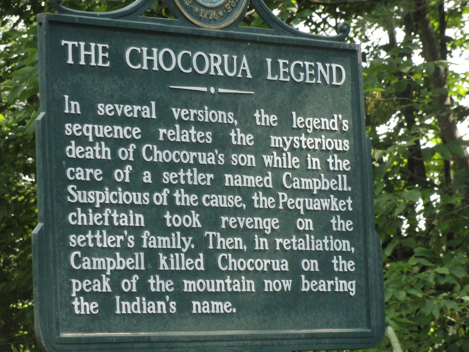
Mount Chocorua Name History
As noted on the Wikipedia web site, there are many versions of the Chocorua legend, one of which is displayed on a historical marker near Chocorua Lake.
Special Memories
• Standing in the middle of Champney Falls with its hundred plus foot drop
• Seeing a Mother Black bear and her cub run across our trail.
• The last few hundred feet climb of Chocorua is grabbing ledges, positioning my feet, and pushing myself up, then re-grabbing, positioning feet, and pushing again, etc.
• Standing on a cloudless seventy-degree day on the summit of Mt Chocorua with a 360-degree view that includes northern New Hampshire’s presidential range, lakes and peakbagger mountains.
 |
Just a few more feet!
|
• This hike in wet weather would be extremely slippery and not recommended for the beginning hiker.
Now, George, Dundee and I never have to say,
“We wish we had hiked Mt Chocorua!”
Steve's latest book,
Outdoor Enthusiast: Never say, "I wish I had..." is now available as an e-book at
Amazon's Kindle and
Barnes and Noble's Nook.
To see all the pictures and videos of our Mt Chocorua hike,
click here.


No comments:
Post a Comment