Monday, December 21, 2015

CERT Net Control Training on Search and Rescue (SAR)

The Bedford, New Hampshire Community Emergency Response Team (CERT) (http://www.bedfordnhcert.org) includes members trained as ham radio operators. To be a ham radio operator a person must pass an Amateur License exam conducted by the Federal Communications Commission Universal Licensing System.  Upon passing the Operator Technician exam a person receives their unique call sign, such as KC1BJI.

An amateur radio net, or simply ham net, is an “on-the-air” gathering of amateur radio operators. Most nets convene on a regular schedule and specific frequency, and are organized for a particular purpose,  such as the Bedford CERT hams use a directed net to maintain and practice their radio communication skills. A formal, or directed net, has a single net control station (NCS) that manages its operation for a given session. The NCS operator calls the net to order at its designated start time, periodically calls for participants to join, listens for them to answer (or check in ) keeps track of the roster of stations for that particular net session, and generally orchestrates the operation of the net.

Tonight I was the NCS person under the tutelage of Ric, Communications Officer of Bedford CERT.

Each week's agenda has a check-in with each person using their Federal Communication Commission assigned call sign.  They also identify the type of power used (such as fixed station commercial power, fixed station emergency power, mobile or Handheld).  Announcements and training education are part of this exercise.  The announcements are items of interest to the CERT members (for example upcoming CERT training sessions and meetings).

Tonight's training session was conducted by Steve.  The training focused on two related search and rescue (SAR) topics of particular importance in rural New Hampshire:
  1. The Hiker Responsibility Code 
  2. Ten Essentials of Hiking
The Hiker Responsibility Code, was developed in 2003 as a joint program between the White Mountain National Forest (WMNF) and the New Hampshire Fish and Game Department (NHFG)The Hiker Responsibility Code was needed when the number of WMNF search and rescue occurrences were increasing because of negligence and ignorance on the part of wilderness hikers.  The costs of air searches and rescues, along with the safety risk to SAR volunteers, were unacceptable.

The Hiker responsibility code is intended to ensure that hikers are equipped with the gear, knowledge and experience they need to have a safe journey into the wilderness.

Knowing the Hiker Responsibility Code and the essential equipment and knowledge (Ten Essentials of Hiking) may save your life in the wilderness, it could also save you being charged thousands of dollars for YOUR search and rescue.  The New Hampshire Fish and Game Department is authorized to sell voluntary Hike Safe Cards for $25 per person and $35 per family. People who obtain the cards are not liable to repay rescue costs if they need to be rescued due to negligence on their part in the wilderness. The card is valuable for anyone hiking, paddling, cross country skiing or engaging in other outdoor recreation. An individual may still be liable for response expenses if they are deemed to have recklessly or to have intentionally created a situation requiring an emergency response.

People who possess a current New Hampshire Fish and Game hunting or fishing license, or a current registration for an off-highway recreational vehicle, snowmobile or boat, are already exempt from repaying rescue costs due to negligence.


Follow the Hiker Responsibility Code
(http://hikesafe.com/)
You are responsible for yourself, so be prepared:
  1. With knowledge and gear. Become self-reliant by learning about the terrain, conditions, local weather and your equipment before you start.
  2. To leave your plans. Tell someone where you are going, the trails you are hiking, when you will return and your emergency plans.
  3. To stay together. When you start as a group, hike as a group, end as a group. Pace your hike to the slowest person.
  4. To turn back. Weather changes quickly in the mountains. Fatigue and unexpected conditions can also affect your hike. Know your limitations and when to postpone your hike. The mountains will be there another day.
  5. For emergencies. Even if you are headed out for just an hour, an injury, severe weather or a wrong turn could become life threatening. Don’t assume you will be rescued; know how to rescue yourself.
  6. To share the hiker code with others.
Voluntary Hike Safe cards are available at http://www.wildlife.state.nh.us/safe/index.html.

Ten + 2 Essentials when Hiking
1. Map
2. Compass
3. Warm Clothing
4. Extra Food and Water
5. Flashlight or headlamp
6. Matches/fire starters
7. First aid kit/repair kit
8. Whistle
9. Rain/wind gear
10. Pocket knife
11. Contractor type 40- gallon trash bags
12. Duct tape
Notice the above Ten + 2.  Most discussions deal with the ten essentials to carry, but personally, I also carry two trash bags and duct tape.

The below two White Mountain National Forest signs say it all when it comes to relating the Hiker Responsibility Code and the Ten Essentials.


For those interested in more Search and Rescue information, see my Blog post Community Emergency Response Team (CERT) Search and Rescue Training http://tiny.cc/wa8e7x,

KC1BJI.  73 (e.g. "73" is hamspeak for "best regards" when signing off).


References

+++++++++++++++++++

"Everyone must do something.  I believe I will go outdoors with family and friends"

My fifth book, Outdoor Play Fun 4 4 Seasons Volume II, is available Feb 2016 and can be ordered by clicking  OutdoorSteve.comOutdoor Play Volume II has trip preparations, routes, and narratives of bucket list places to go. The book will be great to motivate friends and family to make the outdoors a key component of their daily life. If you want 5 or more books signed, send me an email and we can work out the logistics. Amazon has a special where you can order the paperbook and the e-book comes free! Hmm, use the paperbook for bathroom reading – and the ebook as a reference book with links for on-line references, places to go, and videos for bucket list musts!   http://www.amazon.com/dp/098503842X or https://www.createspace.com/5725742


Wednesday, December 2, 2015

Outdoor Play Fun 4 4 Seasons Volume II


I just made my December 2015 publishing date.  You can order at https://www.createspace.com/5725742 or http://www.amazon.com/dp/098503842X


Outdoor Play "Fun 4 4 Seasons" Volume II is a gift for all ages that never gets outdated. Steve Priest’s fifth outdoor book, Outdoor Play, “Fun 4 4 Seasons” Volume II, was published February 2016.

Many of Steve’s expeditions are indeed bucket list items:
  • Northern Forest Canoe Trail;
  • Maine Island Trail;
  • Crossing the fabled Knife Edge trail to the terminus of the northern Appalachian Trail;
  • Paddling the boundary waters of Ontario and Minnesota;
  • A spring hike into Tuckerman’s Ravine to watch extreme skiers on 70 plus feet of snow;
  • Camping in the NH Great North Woods with a near 100% sighting of moose;
  • Allagash Wilderness Waterway;
  • Descending into the Grand Canyon via Bright Angel Trail;
For outdoor persuasions of any age: 
  • Hike to Diana’s Bath;
  • Zip line over the Mt Sunapee treetops;
  • Squam Lakes Natural Science Center to see in their natural habitat “up close and personal” black bear, bobcats and mountain lions;
  • Paddle McDaniel’s Marsh to see eagle, beavers, and other wildlife;
  • Learning to row (like in crewing);
  • There is a chapter on How to be an Outdoor Enthusiast;
  • And much more;
If you want 5 or more books signed, send me an email and we can work out the logistics.  

Order at https://www.createspace.com/5725742 or http://www.amazon.com/dp/098503842X.

See http://www.OutdoorSteve.com for more description.
+++++++++++++++++++

"Everyone must do something.  I believe I will go outdoors with family and friends"

Wednesday, November 18, 2015

Community Emergency Response Team (CERT) Search and Rescue Training


Community Emergency Response Team (CERT) is your neighbors, friends, and co-workers - a collection of community volunteers that want themselves and their town to be prepared in the event of an emergency or disaster.

I am a member of Bedford, NH CERT and the Londonderry, NH ALERT (A Londonderry Emergency Response Team). Their missions are maintaining a trained, dedicated group of volunteers:
1)      Assist their communities and its public safety departments in times of need.
2)      Serve as a community source for education on emergency preparedness and prevention.
3)      Recruit and regularly train volunteer citizens.

Search and Rescue Training (SAR)
I have taken advantage of search and rescue training offered by both the Londonderry ALERT and Bedford CERT. The types of their search and rescue training I have been part of include:

  • Wilderness line search to locate missing persons or objects (SAR).
  • Orienteering – how to read and use a compass and/or map.
  • Red Cross Advanced First Aid certification including CPR, splints, bandaging and transporting patients.
  • Amateur Radio (Ham Radio Operators) within SAR.
 Below are briefs of the above selected CERT and ALERT training exercises, which blend the learned skills for SAR, map and compass, first aid, and ham radio communication.

Line Search and Rescue Training at Musquash Conservation Area, Londonderry, NH


Searches Prepared for a Winter Line Search


Under the general name of Line Search and Rescue training, the ALERT and CERT teams teaches and practices four general steps:

  1. Locate the victim using Line Search Method: Maintain a line of searchers arms-length apart. Walk straight ahead (as best in a wilderness environment). A person behind line guides line to maintain a straight line of search. Left and right end line searchers insure line is staying together. Move through assigned search area looking for signs of distress or hint of missing person or item. See Picture: Searchers Prepared for a Winter Line Search.
  2. Access the victim.
  3. Stabilize the victim by treating any life threatening injuries.
  4. Transport the victim to a safe area for professional assessment.

There is a safety dress inspection to be sure all line searchers are dressed appropriately for the condition of the environment. If someone is unequipped they cannot participate. For example, in winter weather a check is made to insure no cotton clothing is worn. No jeans are allowed. Best fabrics are polypropylene, silk or wicking fabrics on skin layer. Then layers of wool and fleece. Proper footwear, hydration and a snack are needed for an extensive excursion.

For this exercise a body (dummy) is placed within an area and the line search team assigned a section.  When the dummy is found, the team proceeds to provide first aid and then transports the “person” to a safe area.


First Aid Administered On-site

Training was at the Hickory Hill Road trailhead of the Musquash conservation area off High Range Rd. in Londonderry.  Map of Musquash Trails, Londonderry, NH  http://tiny.cc/iyd75x

Orienteering Training by Londonderry NH ALERT at Beaver Brook Association, Hollis, NH

Our Beaver Brook Orienteering GPS Route


Getting a Compass Bearing

There is a Beaver Brook Orienteering Course laid out among the trails where a trainee can apply map and compass skills and off trail navigation.  Each attendee must bring their compass and GPS (if they have GPS), and print a copy of the trail maps and orienteering course. http://www.beaverbrook.org/wp-content/uploads/2011/05/Beaver-Brook-Seasonal-0907-map.pdf

The Londonderry ALERT conducted the training. We combined hiking with a few hours of navigation training with map and compass. We practiced how to read a map, determine a compass bearing, and how to follow that bearing to 9 different points through wooded areas identified on the orienteering map.

Amateur Radio – Ham Radio Operators


Both CERT and ALERT offer instruction in using hand operated radios.  Members practice their radio skills in the SAR exercises. Ham operators have in common a basic knowledge of radio technology, operating principles and regulations, demonstrated by passing an examination for a license to operate on radio frequencies known as the "Amateur Bands." 

These frequencies are allocated by the Federal Communications Commission for use by hams from just above the AM broadcast band all the way up into extremely high microwave frequencies.

Learn more about Amateur Radio at New Hampshire American Radio Relay League Section Web Site http://www.arrl-nh.org/

Map and Compass Training

The UNH Cooperative Extension, provided a two hour class on compass and topographical maps. The presenter emphasized Map, Compass and Pacing, so, “you will know where you are.”
Pacing: We began the class by going outdoors.  The instructor used a measuring tape to lay out a 100 foot distance, and had each member of the class count their normal paces back and forth to get the average number of steps. He wanted us to “memorize forever”, that, in my case, 40 paces closely approximates 100 feet. The Lesson: In the woods with a map, knowing distance can be critical.

Maps: Here are a few map items discussed:
Compass tips:
  • Azimuth is 0 to 360 degrees.  Quadrant is 0 to 90 degrees.
  • Declination – in New Hampshire, magnetic North is 16 degrees west from true North.  Declination is zero degrees west side of the Great Lakes
  • The compass arrow is ALWAYS correct!
  • Box the arrow (north)
  • You can see about 100 feet in the woods of New Hampshire.  Sight on a rock or a tree.
  • Good to know measures:
    • 1 miles is 5,280 feet
    • 1 acre is 43,560 sq. ft. or approximately 208’ x 208’

Compass and Map References (One Page Briefs from Appalachian Mountain Club):


Search and Rescue Bedford CERT and Londonderry ALERT

References:


+++++++++++++++++++

"Everyone must do something.  I believe I will go outdoors with family and friends"

My fifth book, Outdoor Play Fun 4 4 Seasons Volume II, is ready February 2016. Order here by clicking OutdoorSteve.comOutdoor Play Volume II has trip preparations, routes, and narratives of bucket list places to go. The book will be great to motivate friends and family to make the outdoors a key component of their daily life. If you want 5 or more books signed, send me an email and we can work out the logistics. Order at  http://www.amazon.com/dp/098503842X or https://www.createspace.com/5725742


Thursday, November 12, 2015

Kayaking McDaniel's Marsh Wildlife Management Area - Springfield, NH


Two friends and I picked a cloudy day in early November to kayak McDaniel’s Marsh in Springfield, New Hampshire.  We put-in at 9 am and took-out around noon. Indeed, there is a diversity of wildlife at McDaniel's Marsh. 

We began our paddle close to the western shore. McDaniel’s Marsh is generally shallow water with many floating islands of grass and muck.  Its name “marsh” is very appropriate.

Two Bald Eagles
Within five minutes of our put-in Mike spotted a bald eagle.  We sat quietly bobbing in the water, watching our symbol of American freedom on her/his tall treetop perch.  Mike whispered again, “Look, another eagle.”

We watched both birds and listened to the second bird call from its perch.  Then the first eagle flew to the tree of the second eagle.  The birds sort of danced along the same branch in a "let's get to know each other better" fashion.  

 My bald eagle email inquiry to the NH Audubon Society was responded to by Chris Martin, Raptor Biologist.  The bird on the left is a 3.5-yr old (hatched Spring 2012) based upon its whitish head and dark mask and some dark spots on tips of tail feathers. It is probably a female based on its slightly chunkier size. The mottled brown bird on the right is a 1.5 or 2.5-yr old (hatched Spring 2013) based on its yellowing beak, whitish crown, and overall mottled appearance. Possibly a male as it appears to be slimmer. It’s pretty unlikely that they are related to each other, in fact they are probably in transit, as most younger-aged eagles are during the Fall.”

Chris asked if I had any other pictures that might show if the eagles had leg identification bands.  Upon receipt of my additional pictures, Chris emailed he could not see bands on either bird.


Beaver Lodge in left of picture
Signs of beaver were everywhere – from floating beaver chews to lodges both close to shore and self-standing. The shorelines showed beaver paths into the woods where they were seeking trees and limbs for their winter food sources.

Muskrat Pushups
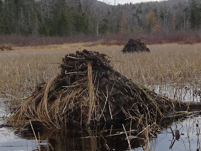
Later we would see muskrat pushups – they somewhat resemble smaller beaver lodges neatly protruding two or three feet above the waterline.

  
Muskrat Pushup

 Is this a Snipe?

Nope. We saw a greater or lesser yellowlegs, which are two rather similar-looking species.


Statistics and References on McDaniel’s Marsh Wild Management Area
http://www.wildlife.state.nh.us/maps/wma/mcdaniels-marsh.html

  • Approximately 2 miles in length and ¼ mile max width.
  • Town:Grafton, Springfield County: Grafton
  • Acres:609
 Acquisition History: Acquisitions to create this WMA began in 1957, and a water control structure was built shortly afterwards. Additional acreage was purchased and added to the WMA over the years using Federal Aid in Wildlife Restoration funds and state duck stamp revenues. Department ownership protects nearly three quarters of the marsh's shoreline.

Description: Three hundred acres consists of a diverse wetlands system located along Bog Brook. A water control structure built in 1958 maintains the conditions for quality waterfowl nesting and feeding habitat on the property. The wetland types on the property include: bogs, forested wetlands, shrub/scrub wetlands, emergent vegetation and deep-water wetlands. The uplands adjacent to the wetland systems are primarily forested, and consist of spruce/fir.

Common Wildlife: There is a diversity of wildlife at McDaniels Marsh. Upland species include moose, white-tailed deer, black bear, mink, ruffed grouse, snowshoe hare and woodcock. Nesting waterfowl include mallards, black ducks, wood ducks, hooded mergansers and Canada geese. The migrant waterfowl at the marsh include blue- and green-winged teal, common goldeneyes, scaup, ring-necked ducks, and scoters. Look for belted kingfishers, yellow-rumped warblers, common yellowthroats, and song sparrows. The wetlands have warmwater fish, including bullheads, Eastern chain pickerel and yellow perch.

Directions: McDaniels WMA is located between Washburn Corner and Route 4-A in Springfield. From Route 4-A in Enfield, turn south onto Bog Road at George Pond. Follow the road for four miles to the junction of George Hill Road at Washburn Corner. The dam, marsh, parking lot and a launch ramp will be on the left.

Bald Eagles
 Bald eagles are legally protected in New Hampshire. Possession and take (which includes harming, harassing, injuring and killing) is illegal.

Distribution: Bald eagles are present year round in NH with pairs breeding and raising young in the spring/summer and many wintering in areas with open water such as Great Bay.

Description:3' tall with a 6-8' wing span. Females weigh up to 14 lbs; males weigh 7-10 lbs. Immature bald eagles are mottled light brown, tan, and white until age 3 or 4. They have brown eyes, a black beak, and yellow feet. Adult bald eagles have a distinctive white head and white tail feathers, and a dark brown body and wings. Their eyes are pale yellow and the powerful beak and unfeathered feet are bright yellow.

Voice: Weak, high-pitched, chatters or whistles.

Habitat: Bald eagles breed in forested areas near bodies of water and winter near open water (i.e. coastal areas, rivers, and lakes with open water).

Nesting: Bald eagles can live up to 30 years old and can begin breeding between 4-6 years of age. They build large nests in tall trees near the water’s edge. Females lay 1-3 eggs in March - May. Both the male and female incubate the eggs and young hatch after five weeks. Bald eagles often retain the same mate for many years and reuse the same nest from year to year.

Diet: Primarily fish; occasionally other birds, small to medium mammals, turtles and with carrion.

Muskrat families build nests, called pushups, to protect themselves and their young from cold and predators. When we first spotted from a distance these muskrat pushups we thought they were beaver lodges as they are somewhat similar, but not as large.  In marshes, push-ups are constructed from vegetation and mud. These muskrat push-ups are up to 3 ft in height

References
+++++++++++++++++++

"Everyone must do something.  I believe I will go outdoors with family and friends"

My fifth book, Outdoor Play Fun 4 4 Seasons Volume II, is now ready for Christmas season. Order here by clicking OutdoorSteve.comOutdoor Play Volume II has trip preparations, routes, and narratives of bucket list places to go. The book will be a great stocking stuffer to motivate friends and family to make the outdoors a key component of their daily life. If you want 5 or more books signed, send me an email and we can work out the logistics. Order at  https://www.createspace.com/5725742 or  http://www.amazon.com/dp/098503842X