Saturday, May 23, 2020

Sunapee-Ragged-Kearsarge Greenway Trail 14 – Chalk Pond to Newbury 4.4 Miles


The Sunapee-Ragged-Kearsarge Greenway (SRKG or Greenway) is a 75-mile “emerald necklace” of fourteen hiking trails surrounding Lake Sunapee, crossing Sunapee, Ragged and Kearsarge mountains, and maintained by Greenway volunteers. The red arrow in the map points to Trail 14 – Chalk Pond Road to Newbury Post Office.  


We started our hike at the northern trailhead at Chalk Pond Road in Newbury, NH. 

The SRK Greenway Guide had the estimated time for this 4.4-mile hike to be 2.5 hours. My fellow hiker, Jim, and I found this to be a 3.5-hour hike. We did stop for a short 10-minute lunch and paused regularly to drink water and snack. This was a somewhat up and down hilly climb through 2 1/2 miles of woods, ending with a 1.5-mile hike on the Old Province gravel road and finishing on route 103 in Newbury.


We referred to the SRK Greenway Guide frequently during our trek. The Guide listed a spur trail NH Audobon Stoney Brook Wildlife Sanctuary from the Skytop Road cul-de-sac, but we did not notice any signs. 

A bit of Newbury town history. In 1778 the town was incorporated as Fisherfield, named after John Fisherfield, who was given a land grant. In 1837 the citizens changed the name to Newbury. 

We had only slim views of 21 acre Chalk Pond.

The Guide rates the hike as moderate. I agree with this due to frequent ups and downhills. Jim and I were both a bit surprised the Guide had this hike estimated as 2.5 hours. 

The hike was in mid-May, 70 degrees, and while we had some black flies, we had no major issue with them.

Sunapee-Ragged-Kearsarge Greenway (SRKG) Trails Hiked by OutdoorSteve and Friends - Click below links
References
    ******************************************
    " Everyone must do something. I believe I will go outdoors with family and friends"
    ++++++++++++++++


    Steve's 6th book is now available. Outdoor Play "Fun 4 Seniors" Volume III has trip preparations, routes, and narratives of bucket list places to go. Motivate friends and family to make the outdoors a key component of their daily life.

    Steve’s books are also available as hardcopy and e-Books at Kindle and Morgan Hill Bookstore, New London, NH
    Colby-Sawyer College, New London, NH, and Dartmouth-Hitchcock Gift Shop, Lebanon, NH.

    Tuesday, May 19, 2020

    Sunapee-Ragged-Kearsarge Greenway Trail 2 Old Province Road to Sunapee Town Hall


    The Sunapee-Ragged-Kearsarge Greenway (SRKG or Greenway) is a 75-mile “emerald necklace” of fourteen hiking trails surrounding Lake Sunapee, crossing Sunapee, Ragged and Kearsarge mountains, and maintained by Greenway volunteers. The red arrow in the map points to Trail 2 – Old Province Road to Sunapee Town Office. The 7.3 miles hike is from the southern trailhead at Old Province Road, a gravel dead-end road in Goshen. The northern trailhead destination is the Sunapee Town Office. 


    A fellow hiker, Mark, joined me in the hike.


    Two days before the hike, my wife and I drove to Old Province Road, an uphill gravel road, ending at a four-car parking area. As we walked around, we were pleasantly surprised to learn we were on the western flank of Mount Sunapee. We spotted snow-making equipment, and we took a short path and found ourselves on top of South Peak and its snow-lift tramway. Given this area looks different in the winter, it took me a few minutes too realized I had skied on this slope. A further surprise was seeing the summit of Mount Sunapee before us. This overlook would be great for a future picnic lunch.
    Summit Mt Sunapee from South Peak
    As you walk down Old Providence Road and Brook Road you see clear views across the Connecticut River of snow covered trails of Okemo Mountain (30+ miles away) and Mt Ascutney (see if you can identify the tower on its summit) and numerous other Vermont peaks. 
    Okemo Mountain, VT

    We learned this SRKG Trail 2 southern trailhead, was also the northern trailhead of the SRKG Trail 1, leading to Newbury Harbor. We scouted two trails in one trip! We saw trail blaze signs for the Monadnock-Sunapee Greenway.
    Mt Ascutney, VT


    Trail 2 starts down Province Road for a 1/2 mile, then a right on paved Brook Road for 1.3 miles, left onto Route 103, and almost immediately takes a right on Harding Hill Road. The hike down Brooks Road has stunning views across the Connecticut River of Mt Ascutney and snow-covered trails of Mt Okomo. A must stop for pictures.

    We went about a mile on Harding Hill Road, seeing the trailhead on the right into the woods. There is parking for four cars across from this trailhead.

    Not lost, just do not know where we are.

    As Mark and I headed into the Harding Road trailhead, I told him a story about hiking a few years ago and needing to backtrack because I missed a trail sign at a turn.

    Well, we walked ten or so minutes, and I asked him if he had seen the Greenway trapezoid sign. He said no, and after discussion, we felt we were on the correct trail. Fifteen minutes later, and we had not seen the SRKG blaze. So as all good hikers do when they do not know where they lost the trail, we turned around and headed back to find the sign we first saw on the trail. Lo and beyond, within a hundred feet of Harding Hill Road, we saw the trapezoid directing hikers to the right. 
    Two days later, for the sake of those following in our footsteps on Trail 2, I returned and trimmed the branch that helped us miss the turn.  

    Interestingly enough, the SRKG trail we were following, was parallel to the snowmobile trail we had initially taken, and the two paths joined at a junction just after we turned around. 

    SRKG Trapezoids.

    For the most part, the paths were well marked. Notwithstanding our oversight of the sign, there were a few spots where we did lose sight of the trapezoids.

    One of us went ahead within sight of the other until the SRKG emblem was again spotted.

    Black Flies

    We both prepared for black flies, but at the start, the temperature was in the high 40’s, and no flies were present. We had no black flies until our last half hour of hiking. At that point, we felt like we were being eaten alive. Why did we not stop and put our repellent or bug nets on? Never gave it a thought as we were almost through with our 7.3-mile hike to the Sunapee Town Hall.

    Habitat

    The 5 ½ mile hike from Harding Hill Road went though maintained snowmobile and XC trails, a few small streams we crossed using its embedded rocks, unmaintained swamp paths, and trails with mud and water. At least three times we had to crawl under blowdowns across the trail. We had a few small hills to climb. Close to the end of the hike, we went down a very long steep treed slope very carefully.

    Our hiking poles came in handy, and our hiking boots and gaiters were a necessity.

    Friendly chats about our hiking, sailing, and kayaking experiences. We ate lunch at an overlook of Mt Sunapee with its snow-covered spring ski slopes. We visited a few spurs recommended in the SRK Greenway Trail Guide. We deviated off the main trail to see a beaver dam, visited a small stone cave noted with a sign reading, Bear Den, and had scenic views of Mt Sunapee, Mt Ascutney, and Mt Okemo.

    Trail 2 is rated moderate by the SRK Greenway Trail Guide. I agree. The 3rd Edition of the book has Spur trails for each listed trail. The Guide is an excellent reference, so you “stop and smell the flowers” on your hike. If you did not make the Riverwalk Loop on Trail 3, it is a must to finish your trek on the Sunapee Harbor Riverwalk. Sunapeeharborriverway.com

    We enjoyed the hike very much!


    Sunapee-Ragged-Kearsarge Greenway (SRKG) Trails Hiked by OutdoorSteve and Friends - Click below links
    1. SRK Greenway Trail 1 Old Province Rd, Goshen to Newbury Harbor
    2. SRK Greenway Trail 2 Old Province Rd, Goshen to Sunapee Town Hall
    3. SRK Greenway Trail 3 Sunapee to Deerhill Springfield (Video featured on Bedford Community TV)
    4. SRK Greenway Trail 4 ProtectworthTrail, Springfield, NH
    5. SRK Greenway Trail 5 Springfield/New London to Great Brook Bridge
    6. SRK Greenway Trail 6 Great Brook Bridge to Wilmot 4A Wolf Trees and Trails
    7. SRK Greenway Trail 7 NH Route 4A to WilmotCenter
    8. SRK Greenway Trail 8 Wilmot Center to New Canada Road
    9. SRK Greenway Trail 9 New Canada Road to Proctor Academy
    10. SRK Greenway Trail 10 Proctor Academy to Winslow State Park Mt Kearsage
    11. SRK Greenway Trail 11 Rollins State Park via Lincoln Trail to Kearsarge Valley Road
    12. SRK Greenway Trail 12 – Kearsarge Valley Road to Wadleigh State Park
    13. SRK Greenway Trail 13 - Kezar Lake at Wadleigh Park to Chalk Pond
    14. SRK Greenway Trail 14 – Chalk Pond to Newbury

    References

    ******************************************
    " Everyone must do something. I believe I will go outdoors with family and friends"
    ++++++++++++++++


    Steve's 6th book is now available. Outdoor Play "Fun 4 Seniors" Volume III has trip preparations, routes, and narratives of bucket list places to go. Motivate friends and family to make the outdoors a key component of their daily life.

    Steve’s books are also available as hardcopy and e-Books at Kindle and Morgan Hill Bookstore, New London, NH
    Colby-Sawyer College, New London, NH, and Dartmouth-Hitchcock Gift Shop, Lebanon, NH.


    Wednesday, May 13, 2020

    Sunapee-Ragged-Kearsarge-Greenway Trail 12 – Kearsarge Valley Road to Wadleigh State Park


    The Sunapee-Ragged-Kearsarge Greenway (SRKG or Greenway) is a 75-mile “emerald necklace” of fourteen hiking trails surrounding Lake Sunapee, crossing Sunapee, Ragged and Kearsarge mountains, and maintained by Greenway volunteers. The red arrow in the map points to Trail 12 Kearsarge Valley Road to Wadleigh State Park.

    This section of SRKG Trail 12 coincides with the Kearsarge Valley Trail. Most of the trail signs show both signs. The trail uses old wood paths, town roads, unmaintained Class VI roads, and new wood trails. We went in early May, and although there we had some wet and muddy areas, and a few tree blowdowns across the path, we found the hiking reasonably easy. We did notice that the black fly season was beginning, and the adage, “Black fly season starts with Mother’s Day and ends with Father’s Day,” appears to hold. The level of difficulty in the SRK Greenway Trail Guide is “easy,” and based on this hike, we agree.


    The eastern trailhead is on Kearsarge Valley Road, about 3.9 miles from Route 11 in Wilmot Flat. On our east-to-west direction hike, we passed 55 acres Gile Pond Sutton, NH.

    The Western Trailhead is at Wadleigh State Park on 170 acre Kezar Lake in North Sutton. The picture of Mount Kearsarge was taken on the one-lane bridge over Lane River. 


    According to the SRK Greenway Trail Guide, “Gile Pond is part of the Lane River, running south through Kezar to the Warner River. The theory is that Kezar Lake, elevated by a small dam, and Gile Pond were once one body of water. Only six feet in elevation separate the ponds, and the terrain between them is wetlands and a sandy plain. Gile Pond was one of the many New Hampshire ponds in which logs were placed for storage after the 1938 hurricane. Logs from trees downed by the storm but not recovered are seen breaking the pond’s surface."

    We passed by a “glacial erratic” rock before crossing route 114. I have noted many “glacial erratic” rocks hiking along other SRKG trails. Speaking of noticing things, we spotted a mammoth “wolf tree” that was cut just after we crossed Route 114 and entered the woods. Trail 6 brings attention to wolf trees, and I briefly discussed them in my Trail 6 blog post referenced below.


    Sunapee-Ragged-Kearsarge Greenway (SRKG) Trails Hiked by OutdoorSteve and Friends - Click below links
    1. SRK Greenway Trail 1 Old Province Rd, Goshen to Newbury Harbor
    2. SRK Greenway Trail 2 Old Province Rd, Goshen to Sunapee Town Hall
    3. SRK Greenway Trail 3 Sunapee to Deerhill Springfield (Video featured on Bedford Community TV)
    4. SRK Greenway Trail 4 ProtectworthTrail, Springfield, NH
    5. SRK Greenway Trail 5 Springfield/New London to Great Brook Bridge
    6. SRK Greenway Trail 6 Great Brook Bridge to Wilmot 4A Wolf Trees and Trails
    7. SRK Greenway Trail 7 NH Route 4A to WilmotCenter
    8. SRK Greenway Trail 8 Wilmot Center to New Canada Road
    9. SRK Greenway Trail 9 New Canada Road to Proctor Academy
    10. SRK Greenway Trail 10 Proctor Academy to Winslow State Park Mt Kearsage
    11. SRK Greenway Trail 11 Rollins State Park via Lincoln Trail to Kearsarge Valley Road
    12. SRK Greenway Trail 12 – Kearsarge Valley Road to Wadleigh State Park
    13. SRK Greenway Trail 13 - Kezar Lake at Wadleigh Park to Chalk Pond
    14. SRK Greenway Trail 14 – Chalk Pond to Newbury
    References

    ******************************************
    " Everyone must do something. I believe I will go outdoors with family and friends"
    ++++++++++++++++


    Steve's 6th book is now available. Outdoor Play "Fun 4 Seniors" Volume III has trip preparations, routes, and narratives of bucket list places to go. Motivate friends and family to make the outdoors a key component of their daily life.

    Steve’s books are also available as hardcopy and e-Books at Kindle and Morgan Hill Bookstore, New London, NH
    Colby-Sawyer College, New London, NH, and Dartmouth-Hitchcock Gift Shop, Lebanon, NH.

    Saturday, May 9, 2020

    Sunapee-Ragged-Kearsarge Trail 3: Sunapee Town Hall to Deer Hill Road


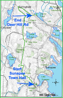
    The Sunapee-Ragged-Kearsarge Greenway (SRKG or Greenway) is a 75-mile “emerald necklace” of fourteen hiking trails surrounding Lake Sunapee, crossing Sunapee, Ragged and Kearsarge mountains, and maintained by Greenway volunteers.  The red arrow in the map points to Trail 3 Sunapee Town Hall to Deer Hill Road, Springfield. 


    The trapezoidal white and green trail blaze is the trademark of the Greenway. When hiking, keep these trapezoids insight, and you know you are on the SRKG trail.


    The southern trailhead of the SRKG Trail 3 is at the Sunapee Town Office, on NH Route 103B just south from its junction with NH Route 11. Parking is to the left of the Sunapee Town Office, close to the Sugar River. The northern trailhead at the intersection of Stoney Brook Road and Deer Hill Road is in Springfield, NH.

    The Sunapee Riverwalk and SRKG trailhead signs outside the

    Sunapee Town Hall are on the same post because the trails loop and overlap in Sunapee Harbor.

    As I finished this loop, I again hiked over the footbridge at the trailhead, this time crossing route 11 and taking a left on Lower Main Street, and then a right onto School Street where I entered the woods for ¼ mile ending up in a neighborhood cul-de-sac.

    There the trail follows Sargent Road to North Road, up a steep hill for another ¼ mile, then a right on Hill Top Drive, a gravel road that takes a sharp left and returns to North Road. A right on North Road, and you continue for two or so miles straight ahead, then North Road  extends past a Dead End sign, then one mile gravel to a forked road where the trail with its trapezoid blazes enters a gated Class VI road. 
    The Class VI road is not town maintained. This one-mile section has ruts, muck, water run-offs crossing the trail, and follows a stonewall ... all the while going uphill. This is a very straight trail and brings you to paved Hogg Hill Road. You then go left on Hog Hill road meeting Stoney Brook Road, from whence you take a right for a mile, until just under Route 89 you come to Deer Hill Road – a dirt road. This is the northern  trailhead of Trail #3. The Trail #4 trailhead sign, Protectiveworth Trail, continues you on to the next trail of your SRKG journey.

    Trail 3 has been fascinating for me. I have hiked and run many of Sunapee's roads and woods trails, but rarely paid attention to the trapezoid signs.  Trail 3 was done in three separate hikes. First was the southern trailhead at the Sunapee Town Office to School Street by the Sunapee Elementary School. The second was from the Sunapee Elementary School to the Class VI unmaintained road at the end of the gravel section of North Road. The third is hiking from the gated Class VI road at the end of the gravel section of North Road to the SRKG northern trailhead at the junction of Stoney Brook Road and Deer Hill Road.


    I produced three separate videos for each of my three SRKG Trail 3 section hikes. The below video merges these videos into the full 7.3 mile hike with a prelude by OutdoorSteve. 

    Grab a cup of coffee or another favorite beverage, find a comfortable lounge chair, kick up your feet, and enjoy the below video, as Steve and Cathy hike Trail 3 of the Sunapee-Ragged-Kearsarge Greenway from Sunapee to Springfield, New Hampshire.


    The SRK Greenway Trail Guide rates Trail 3 as moderate, and we are in agreement.  The Guide's estimated time for this 7.3 mile hike is 3 hours. I find this time very fast. I spent a 1/2 hour on the Sunapee Riverwalk loop, as I stopped at each kiosk to learn the uniqueness and history of Sunapee Harbor and the Sugar River.  I also spent three separate trips to hike the whole trail.
    SRKG Completion Medal

    Now prepare yourself for a hike, get yourself a partner, stay two hiking poles apart, and never say, "I wish I had hiked the Sunapee-Ragged-Kearsarge Greenway.

    Sunapee-Ragged-Kearsarge Greenway (SRKG) Trails Hiked by OutdoorSteve and Friends - Click below links
    1. SRK Greenway Trail 1 Old Province Rd, Goshen to Newbury Harbor
    2. SRK Greenway Trail 2 Old Province Rd, Goshen to Sunapee Town Hall
    3. SRK Greenway Trail 3 Sunapee to Deerhill Springfield (Video on Bedford Community TV)
    4. SRK Greenway Trail 4 ProtectworthTrail, Springfield, NH
    5. SRK Greenway Trail 5 Springfield/New London to Great Brook Bridge
    6. SRK Greenway Trail 6 Great Brook Bridge to Wilmot 4A Wolf Trees and Trails
    7. SRK Greenway Trail 7 NH Route 4A to WilmotCenter
    8. SRK Greenway Trail 8 Wilmot Center to New Canada Road
    9. SRK Greenway Trail 9 New Canada Road to Proctor Academy
    10. SRK Greenway Trail 10 Proctor Academy to Winslow State Park Mt Kearsage
    11. SRK Greenway Trail 11 Rollins State Park via Lincoln Trail to Kearsarge Valley Road
    12. SRK Greenway Trail 12 – Kearsarge Valley Road to Wadleigh State Park
    13. SRK Greenway Trail 13 - Kezar Lake at Wadleigh Park to Chalk Pond
    14. SRK Greenway Trail 14 – Chalk Pond to Newbury
    References
    ++++++++++++++++++
    "Everyone must do something. I believe I will go outdoors with family and friends"
      Sunapee, NH: Steve Priest’s latest book Outdoor Play Hiking New Hampshire’s Sunapee-Ragged-Kearsarge Greenway: 75 Miles on a Fourteen Trail Loop, was released December 1, 2020.


      The Sunapee-Ragged-Kearsarge-Greenway (SKRG) Trail is a hidden gem of New England. Outdoor Steve’s goal is to share each step and strategy of this hiking journey across the Lakes Region of New Hampshire. 

      Steve recommends the eBook to experience the uniqueness of Hiking New Hampshire’s Sunapee-Ragged-Kearsarge Greenway Trail. (https://www.amazon.com/gp/product/B08MDN1S16)

      Steve shares a video of his personal experience on each specific trail. The videos make the hike “come alive.” Each trail story is a short read with tips, details on preparation, pictures, maps, and references. The book is also available in paperback.

      Some folks call outdoor experiences “play.” If “play” is defined as the choice made to take a course of action based on the rewards of participation and getting a perspective that can only come from ‘doing,’ then outdoor adventures are play. Many adults and children do not play enough.

      Steve’s books are available as hardcopy and e-Books at Kindle and hardcopy at Morgan Hill Bookstore, New London, NH, Colby-Sawyer College, New London, NH, and Dartmouth-Hitchcock Gift Shop, Lebanon, NH.

      Outdoor Play has trip preparations, routes, and narratives of bucket list places to go. The book will motivate friends and family to make the outdoors a key component of their daily life. If you want 5 or more books signed, send Steve an email  and we can work out the logistics.


      Additional Sources of Books at: