This recently
identified video was made by Frank Crosby as he interviewed Tim Priest heading
for eight days of paddling and tenting on the 92-mile North Maine Woods
Allagash Wilderness Waterway in July 2009.We call this particular trek a Father-Son
trip as the expedition of ten was made-up of four Dads and their sons and
one friend.
Tim has been on many
wilderness paddling trips guided by Master Maine Guide Linwood “The Loon”
Parsons and his wife Betty “The Chickadee”.Tim shares his reflections on Linwood and Betty and his Maine North
Woods trips.
The video includes
pictures from this Allagash Wilderness Waterway trek.
Thank you to Frank
Crosby for sharing this interview.
My friend Mark sent an email inviting his fellow
outdoor enthusiasts to a moonlight snowshoe in the fields and woods of Benedictine Conservation Land and Van Loan Preserve in Bedford, New Hampshire.Both areas are next to each other separated
by Wallace Road.
These properties are
protected by The Bedford Land Trustwith conservation easements and allow
public access to the trails for passive recreational use that remain in place
forever. They were perfect for our snowshoeing quest.
Snowshoeing
Benedictine Conservation Land
On a clear moon lit night in December nine (9)
Outdoor Enthusiasts met at the Benedictine Conservation Land parking lot. The temperature was a mild 18 degrees F.
From the Kiosk leading
to the Benedictine field we went clockwise on the Perimeter Trail climbing up
the open field hill just inside the tree line.We completed the loop passing the Kiosk in about 15 minutes.
We then crossed Wallace
Road to the woods of the Van Loan Trail
Van
Loan Preserve
The Van Loan
Trail is initially a narrow trail through the woods before crossing Riddle
Brook Bridge.Thereafter the Van Loan Trail
reaches a Junction whence we snowshoe onto the Anna and Pic Loop trail counterclockwise.
The
Anna and Pic Loop shortly returns to the Van Loan Trail from where we turn
left back to the Junction of the Anna
and Pic Loop.
We
re-cross Riddle Brook Bridge following the Van Loan Trail to Wallace Road and the Benedictine Parking area.
The
total snowshoe trek was about an hour and forty-five minutes.
The
videos you are about to see are generally dark because the only light was that
of our headlamps and the light of the moon.I have left these black videos to give you a sense of hiking in the dark led
by shining headlamps and the voices of fellow snowshoeing
enthusiasts.
It
was a magnificent night.Wonderful
friends. Beautiful clean country air.Enjoy this short video of snow shoeing in
Bedford, New Hampshire.
"Everyone must believe in something. I believe I'll go outdoors." – S. Priest
Philadelphia Museum of Art - The 72 Steps of Victory
The 72 stone steps leading to the entrance of the Philadelphia Museum of Art in Philadelphia have become known as the "Rocky Steps". The steps were part of the triple-Oscar-winning film Rocky and four of its sequels, Rocky II, III, V and Rocky Balboa. The eponymous character, Rocky, runs up the steps to the song "Gonna Fly Now". (http://en.wikipedia.org/wiki/Rocky_Steps)
"Everyone must believe in something. I believe I'll go outdoors." – S. Priest
Christmas and Holidays are coming. Give Outdoor Play, “Fun 4 4 Seasons” ($11.95) as a reading gift for a life-time of family outdoor motivation.
On
a recent fall Sunday in Elkins, NH, family and friends had the
pleasure of making apple cider while enjoying apple donuts, caramel covered apples, apple bobbing, and apple slices with cheese - all topped off with a reading of Robert Frost's poem, ”After Apple Picking”.
We
made Apple Cider the New Hampshire way:
1) Pick the apples
2) Wash the apples
3) Cut apples into four quarters
4) Put quartered apples through a masher
5) Press the mash for the apple cider.
6) Bottle the cider
7) Sip and enjoy the cider
Below is a short
video of our family oriented day:
"Everyone must believe in something. I believe I'll go
outdoors." – S. Priest
Bedford Community TV Bedford Community TV (BCTV) is now playing
Making Apple
Cider in New Hampshire with Robert Frost’s, “After Apple Picking”. Check their Channel 16 schedule. Christmas and Holidays are coming. Please consider giving Outdoor Play, “Fun 4 4 Seasons” ($11.95) as a reading gift for a life-time of outdoor motivation.
Day 1: Kayaking the Herring River Estuary of Wellfleet and Truro John invited Dundee and I to Cape Cod for two days of kayaking. Day one was planned to be a full day paddling around
Wellfleet Harbor. However, our plan was short-lived when we explored the
Herring River Estuary, a tidal river with a history of bygone prominence.
.
We proceeded west along the shoreline from kayak landing next to the Wellfleet
pier. As we neared Chequessett Neck Road, and the dike at the mouth of the
Herring River, John recalled a recent newspaper article on this dike built in 1909 when it significantly reduced tidal flow to the salt
marsh on the other side of the Road. This dike transformed the estuary into one of the
Cape’s most degraded natural resources.
In 2007 the Towns of Wellfleet and Truro and the Cape Cod
National Seashore signed a Memorandum of Understanding to cooperate on the
development of a restoration plan for the Herring River.
It is expected that when the existing tide gate structure at
the mouth of the Herring is replaced, along with
other upstream considerations, that this significant change will restore and provide full tidal
flow to the Herring River Estuary and a promise for shell-fishing and other community opportunities.
We had before us an opportunity to see a "before" peek of the Herring River Estuary - with an incentive for us to return for an "after" look of the restoration on the environmental vitality of the Herring River Estuary.
We decided it would be worth our effort to portage over Chequessett
Neck Road and paddle up the Herring River.
The Herring Run in
Middleboro, MA
As we paddled along the Herring River I recalled to my
friends how as a youngster I used to visit the Herring Run on the Nemasket River,
Middleboro, MA. Each spring, herring migrate from the ocean, up coastal rivers and
into tributaries and lakes to spawn. The
herring were so plentiful you felt you could walk across their backs on
the river – and so hundreds of people would come to see them. Friends and I would go to the fish ladders
and catch herring with our hands and sell them to people. I remember coming home soaked and with coins
in my pocket from selling my herring catch to people for food and garden fertilizer. It was a marvelous memory
– and my connection to the Herring River Estuary.
Our paddle up the Herring River was well worth the expedition
of nearly seven miles in five hours up and back on the Herring River Estuary:
We saw Swans, Great Blue
Heron, Osprey, Red Wing Blackbirds and other birds.
Many times we thought we
were at the end of the river and about to turn back, but we managed to
find a path through the narrowing quagmire of brush, prickly bushes and marsh
weeds.
We passed under old wooden
plank bridges.
We went through culverts under
tar and dirt roads.
At about three hours mark we
found a road sign that told us we were passing the intersection of Bound
Brook Island Road the Atwood Higgins House.
If you are interested in more information, or to stay up-to-date
on the Herring River Estuary, please visit Friends of Herring River.
They have an email newsletter.
Day 2: Paddling the
Mashpee River and Popponesset Bay, Cape Cod, MA
Day two’s paddlers were Tim, Rob, John, Dundee and I.
We put-in at Pirates Cove in Popponesset Bay.
Paddled up the tidal Mashpee River.After an hour or so, we were in marsh weed,
and decided to return to Popponesset Bay.
Paddled around Popponesset Island.Beautiful homes and boats/yachts.
Lunch on the sandbar protecting Popponesset Bay
Crossed Popponesset Bay to Pirates Cover in choppy water and
wind.
To see a more detail video of our Herring River kayak trip, CLICK HERE for a nine minute video
+++++++++++++++++++
"Everyone must do something. I believe I will go outdoors with family and friends"
My fifth book, Outdoor Play Fun 4 4 Seasons Volume II, is now ready. Order here by clicking OutdoorSteve.com. Outdoor Play Volume II has trip preparations, routes, and narratives of bucket list places to go. The book will motivate friends and family to make the outdoors a key component of their daily life. If you want 5 or more books signed, send me an email and we can work out the logistics. Order at https://www.createspace.com/5725742 or http://www.amazon.com/dp/098503842X
"Everyone must believe in something. I believe I'll go outdoors." – S. Priest
In mid-September 2013 three friends and I will be hiking Mt Katahdin in Maine’s Baxter State Park. Mt
Katahdin is the northern terminus of the Appalachian Trail. One of the trails leading to the summit is
known as The Knife Edge.
We expect this hike to
be between nine (9) and eleven (11) hours over very rough terrain. We must be physically fit. As preparation for this trip, our group has
been doing hikes of varying distances and difficulties. Each hike offers unique and beautiful
scenery of New Hampshire. Our focus was on endurance and distance.
We carried day packs containing similar contents as we will have in September. We had the same amount of water we will need for the Katahdin hike as well as gear (e.g. at least 48
ounces of water, rain coat, winter hat, first aid pack, whistle, map,
compass, camera, two light source headlamps, duct tape, two contractor 30 gal
bags for emergency shelter, bivy sack.)
NH - Central East
White Mountain National Forest, Waterville Valley Exit 28 - Route 93
Location:
Thornton, NH
Rating:
Moderate/Difficult
Route Summary
This is a loop hike across the summits of
Welch and Dickey Mountains, providing many views along the way as the trail
winds its way across open ledges. It follows the yellow-blazed Welch-Dickey
Loop Trail all the way. The different branches of the loop are commonly
referred to as Welch Mountain Trail (the right-hand fork which leads most
directly to Welch); and Dickey Mountain Trail (the left-hand fork which goes
directly to Dickey Mountain.)
Start on
the Welch-Dickey Loop Trail which will fork after just 15 yards.
Take the
right-hand branch to approach Welch Mountain first. (The return trip will
be via the opposite leg.)
After 1.3
miles on the Welch-Dickey Loop Trail, you will reach the open ledges and
extensive views on the southern flank of Welch Mountain.
Continue
following Welch-Dickey Loop Trail and you will reach the summit of Welch
Mountain 0.6 mile later where you will be treated to a 360-degree
panorama.
Descend
the opposite side of the peak, continuing to follow the Welch-Dickey Loop
Trail in a northerly direction.
You will
then need to do some uphill climbing before reaching the summit of Dickey
Mountain 0.5 mile from Welch's peak. Dickey Mountain offers views of
Franconia Ridge and Franconia Notch. Shortly before the summit, there will
be a poorly marked 0.2-mile spur path on the right leading to an open
ledge also with an outlook to the north.
Still on
Welch-Dickey Loop Trail, descend from Dickey's peak in the opposite
direction from which you climbed it.
After 2.1
miles, you will be back at the fork near the beginning of the loop. Bear
right to return to the parking lot.
Click the below 8 minute video as Dundee and I share our training for the Katahdin
climb by hiking the Welch-Dickey Loop Trail.
"Everyone must believe in something. I believe I'll go outdoors." – S. Priest ------------------------------
My adult
son Shaun and I are fellow triathletes. Is it possible we could get my grandson Carson in the same triathlon?
Teenage
friends of my thirteen year-old grandson, Carson, ask me if he might be
interested in being a teammate on their triathlon team they were putting
together. They wanted Carson to do the ¼
mile swim leg – the initial leg of the swim-bike-run triathlon.
A
telephone call to my son Shaun asking if my grandson might be interested had a
response of “Ask Carson”.
A
follow-up text message from Carson, met with a one word response, “Yes!”
Carson’s
positive reply peaked my interested in being in the same race, so I registered, as Shaun did, as
an individual entry to do all three legs.
Two
weeks before the race, I experienced a hamstring injury. While I could swim and bike with this injury,
I knew I could not complete a 3.1 mile run.
Hmm,
maybe since Carson was starting the first leg for his team, I might ask Carson
to do my third leg – the run? Would the
race officials allow this? Would the
officials allow me to change my registration from an individual entry to a team
entry?
I
contacted the person responsible for the race registration; I explained my injury
situation; asked if I could change from an individual entry to a team entry;
and asked if my grandson, Carson, who was already registered on another team
for the first leg, could do my third leg - the run. Her response was a very affirmative “YES!” to
all my questions and concerns (I did need to increase my registration fee as
the team fee is higher than an individual entry.)
Perkins Pond Team
The Priest’s
Shaun
Swim
Carson
Steve
Shaun
Bike
Christian
Steve
Shaun
Run
Nicholas
Carson
Shaun
The
above chart shows my grandson and I start the race as competitors in the swim,
and finish as teammates with his run.
Fantastic!
Enjoy
the below four minute video as three generations of the Priest family enjoy the
New London New Hampshire Triathlon .
"Everyone must believe in something. I believe I'll go outdoors." – S. Priest ------------------------------
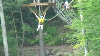
My sixteen year old granddaughter, Madison,
thirteen year old grandson, Carson, son Tim, and grandmother (Wife) Cathy, saw the below video of Sarah and I on the Mount Sunapee Canopy Zip Line Tour, and expressed their desire to never say, “I wish I had been on the Mt Sunapee Canopy Zip Line.” A week later all four achieved their
wish.
What is a zip line? Well, a zip line (also known as a zip wire, aerial runway, aerial rope slide, death slide, flying fox, or canopy tour) consists of a pulley suspended on a cable, usually made of stainless steel, mounted on an incline. It is designed to enable a user propelled by gravity to travel from the top to the bottom of the inclined cable by holding onto, or attaching to, the freely moving pulley. (https://en.wikipedia.org/wiki/Zip-line).
The Mount Sunapee Canopy Zip-Line Tour features a series of zip lines, rope bridges and rappelling as you descend from the top of Mt Sunapee’s South Peak. There are eight zip lines in total highlighted by the final leap on 1,000' dual zip lines which end on a platform behind the Welcome Center, from where we rappelled back down to earth. From the first tree platform to the last platform we traveled a total distance of almost ¾ mile as we flew above forest floor. Groups of no more than eight people are led by two guides as you fly through a canopy of oak, beech, maple, birch and evergreen trees. There are six ski trail crossings that offer spectacular views of the surrounding mountains and Lake Sunapee. [http://www.mountsunapee.com/mtsunapeewinter/index.asp .]
Click the Below Video and Go on Our Zip Line Tour
See Sarah and Steve on Their Zip Line Tour
My wife and I had visitors from Georgia. Sarah, their sixteen year old daughter, heard about the Mount Sunapee Canopy Zip Line Tour. Sarah, being a fellow outdoor enthusiast, wanted to do the Zip Line Tour – and so did I.
Sarah and I were the only people in our group, and our tour took less than two hours.
To qualify as to who can go on the zip line tour, you must be 10 years old or older and between 80 and 260 pounds.
We had two excellent guides, Mary and Martha. They absolutely were part of the positive experience of doing this adventure – and they insured our safety.
Safe at All Times
The Clip-In With each platform, the moment we reached the platform we were clipped to the tree – not once but two times. We could not fall off the platform if we slipped, stumbled, or were pushed. As Sarah and I took turns jumping first, we remained clipped to the tree until we were positioned, and one by one – a clip was release and then re-clipped to the zip line. Thus, again, in case we jumped or slipped before being ready or instructed, we still would not fall from the platform.
Before each jump, we received instruction pertinent to the particular zip line, bridge, or belay we were about to do. [Belaying refers to a variety of techniques climbers use to exert on a climbing rope so that a falling climber does not fall very far. A climbing partner typically applies friction at the other end of the rope whenever the climber is not moving, and removing the friction from the rope whenever the climber needs more rope to continue climbing. The term "belay" also means the place where the belayer is anchored; this is typically a ledge, but may be a hanging belay, where the belayer is suspended from protection in the rock, or in our case the wooden platform [http://en.wikipedia.org/wiki/Belaying ].
Before each of the eight leaps, Mary or Martha would explain what to do, and then the guide would go first with her leap – this served both to demonstrate and to have the guide at the end of the zip line.
The guide at the beginning of the zip line would wait for the guide at the other end to yell “Clear”, and then confirm it with a “clear” – and then I/Sarah would jump.
The First Leap
We rode the Sunapee Ski lift to South Peak to our first platform. We then climbed about fifteen feet on a rope ladder up the hillside platform. Now came the moment I was there for – the zip line leap.
I must confess my stomach was tight for this first jump – and I was sweating with nervousness and anxious anticipation. I looked downhill at the next platform hundreds of feet away, and thought, “What am I doing here?” I had all kinds of reservations as to whether I “really really” wanted to jump from this height. Would the harness hold me? Was I strong enough to hold on to the harness strap (no worry here as the harness cable strap was simply to give me “confidence.”)
My first jump was here. I was all clicked to the cable, and Maratha said, “OK Steve, you can jump.” I looked at Martha to be doubly positive I heard her correctly, and asked, “Is it OK to jump?” [It never hurts to be absolutely certainly about this.]
You have to believe in the equipment and in your guides!! The adrenaline rush came and the commitment was there. I Leaped!!! The harness held and I was flying down the cable with an eagle’s view of Mount Sunapee and Lake Sunapee. It was a thrill!!
The Leap of Trust
With each zip line jump I gained confidence in myself. As I readied for the fourth zip line leap, Mary asked, “Do you want to try the “Leap of Trust?” I questioned her, and she said, “You jump off backwards without holding on to the harness strap. Watch me.” She took a short run off the platform and jump backwards into the open sky! You will need to watch the below video to see if I made it.
How to Dress
The Zip Line tour operates rain or shine, so you must dress appropriately. They recommend hiking boots or sneakers, and no open-toed shoes, sandals, or other footwear that can fall off. Sarah and I both wore sneakers - and this was perfect for us in warm summer weather.
In the summer it is suggested that participants wear shorts that fall mid-thigh or lower and either short or long sleeves. No tank tops are allowed as the harness straps may cause discomfort. They provided all needed safety equipment including a helmet and zip line harness. You may also want to bring sunscreen, bug repellent, a small pack or fanny pack for cameras, snacks, etc.
You need to watch the below video to see Sarah and my first leap, our “Leap of Trust”, rope bridge crossing and belaying.
To see more detail on our Mount Sunapee Canopy Zip Line Tour I have prepared an 11 minute video. Click Hereto see the unedited thrills of the Zip Line.
Winter Wild Race at
Mount Sunapee, Newbury, New Hampshire
Mount Sunapee is an outdoor enthusiast’s four season paradise. The Zip Line Canopy Tour was not my first
time on the mountain. I have hiked and alpine and
telemarked skied here, and done many triathlons from this glorious and
beautiful area.
A special winter experience at Mount Sunapee is called a Winter Wild Race that is a cold
weather race on snow around the perimeter of Sunapee’s ski area.
Winter in New Hampshire offers unique and exciting
opportunities for outdoor enthusiasts. In one of my blog posts I share my training
and research in preparation for running a race up the ski slopes of Mt Sunapee
in temperatures around ten degrees.
Steve's latest book, Outdoor Play "Fun 4 4 Seasons" is now available in paperback and e-book at OutdoorSteve.com and Amazon.com. Outdoor Play has more adventures at Mount Sunapee and Places to Play in Northern New England.
Purchase at www.amazon.com and www.outdoorsteve.com
About OutdoorSteve
OutdoorSteve is more than just a blog; it is a way of life. OutdoorSteve is Steve Priest sharing his outdoor adventures and life experiences. OutdoorSteve includes blog posts, books, short stories, videos, lectures, and speaking events. To learn more or to book Steve for your next event email Steve atsteve@outdoorsteve.com or visit him on the web at OutdoorSteve.com
Outdoor Enthusiast provides outdoor places to go and things to do. Steve's mission is to motivate and encourage families and individuals to make the outdoors a key component of their daily life.
Readers are encouraged to post and share their Comments.
When trying to explain my enthusiasm for outdoor actions, I paraphrase Thoreau's, "Discover I had not lived" with the expression, "Never say, 'I wish I had'."
The book provides places to go and things to do, but moreover the author’s stories and “I wish I had…” show individuals can, like the author, overcome self-made barriers and obstacles of health, physical, mental, and injury problems.
My outdoor pursuit began after a torn Achilles tendon, a resultant limp, and weight gain. I turned to physical activity in search of a stress reliever as well as a "lifestyle for the long haul."
My writings on 'Outdoor Play' enthusiastically portray the entertainment of the outdoors. Travel with me and meet the challenges of outdoor recreation that are the cornerstone of my lectures and stories.
I reside in Sunapee, New Hampshire with Catherine, my wife. We have two sons and two grandchildren.
If you're interested in having me speak, you can email me at steve@outdoorsteve.com or visit www.outdoorsteve.com.