Mike Farley, Manchester Community
Television (MCTV) producer and weekly co-host of The Progress Report Live, asked Steve to join him on his weekly one hour TV show
and discuss Steve's New Hampshire outdoor experiences.
Steve shared his mission to motivate and encourage families
and individuals to make the outdoors a key component of their daily life. Steve outlined his approach in “Making the
outdoors a lifestyle for the long haul.”
Below is a 50-minute video of The Progress ReportLive, November 16, 2016. Steve and Mike chatted on:
“Everyone should believe in something … I
believe I will go OUTDOORS!”
Never say, “I wish I had …”.
Up is optional – Down is Mandatory.
Down is Option – Up is Mandatory.
How to get started in becoming an outdoor
enthusiast.
Steve’s latest New Hampshire outdoor activity.
One of Steve’s favorite New Hampshire outdoor
trips – the Great North Woods of NH.
Steve’s outdoor books offer references and galore
for New Hampshire outdoors fun.
Steve’s e-book versions have videos of Steve
with his family and friends in their many New Hampshire outdoor adventures.
"Everyone must do something. I believe I will go outdoors with family and friends"
Steve's 5th book, Outdoor Play Fun 4 4 Seasons Volume II, is now available (2016).
Outdoor Play Volume II has trip preparations, routes, and narratives of bucket list places to go. The book will motivate friends and family to make the outdoors a key component of their daily life. If you want 5 or more books signed, send Steve an email send Steve an email and we can work out the logistics.
My long term adventurer friend John called and asked if I wanted to hike two days in early November in the White
Mountains of New Hampshire He had picked Mt Tecumseh and Mt Osceola, both
in the Waterville Valley area, and both described as moderate 4,000-foot mountain hikes.
Two-days and Two Four-Thousand Footers Mt Tecumseh and Mt Osceola
Timothy, my son and fellow long-term adventurer, and his friend Rob would be
joining us for the Tecumseh hike.
Day 1 - Mt Tecumseh
A Selfie at Mt Tecumseh Trailhead
Mt Tecumseh is 4,003 feet, and the shortest of the 48 New Hampshire 4,000 foot mountains.
The Mount
Tecumseh trail ascends Mt Tecumseh, starting at the Waterville Valley Ski area
with the trailhead at the top right edge of the parking area. It climbs the east slope of
Tecumseh.
Starting at the
trailhead sign we used exposed boulders and rocks to cross a small brook and follow the
south side of Tecumseh Brook for 0.3mi., then crossed the brook again to a
section along a small ridge. At 1.1 mi.,
the rock bound trail drops down and recrosses the brook, then climbs to
intersect an old logging road. A view sign
points to the edge of the ski slope for good views of the North and Middle Tripyramid Mountains.
Continuing
upward on the rocky trail, we began to get sights of snow and ice. We carried
crampons/micro spikes, but we did not put them on. Not wearing our spikes was a a bit foolish because it would have made our hike a bit more sure-footed.
Boulders, snow, and ice beginning at 1 mile
The main trail
turns right and follows the rock-strewn road, angling upward along the south
side of the Tecumseh Brook valley, then climbs steadily to the main ridge crest
south of Tecumseh, where it turns right in a flat area. Here at 2.2 mi. the Sosman Trail enters from
the left.
We were not sure
whether to follow the Sosman Trail to the summit, or the Mount Tecumseh Trail,
as both arrive at the summit. We
referenced our notes from the AMC White Mountain book, and decided on the Mt
Tecumseh Trail.
At this fork we
took the Mt Tecumseh Trail as it swings right, descends slightly to circle the
base of the steep cone, and finally climbs steeply to reach the summit from the
north at 2. 5 miles from the trailhead.
The summit
offers a majestic view of 6,288 foot snow-capped Mt Washington, the only mountain
covered with a snow. We also saw
neighboring Mt Osceola, which we will hike the next day,
Snow-covered Mt Washington viewed from Mt Tecumseh
The White
Mountain guide says our trip should average 2 hr. 20 min. We took 3 hr., with me continually pulling up
the rear of our four pack.
Mt. Tecumseh - Sosman Trail
We decided to
return to our parking area from the summit by the Sosman Trail, which connects
the summit of Tecumseh with the top of the Waterville Valley ski slopes. The
Sosman trail sign is clear with an arrow, and leaves the summit along the ridge
to the south, then turns to the west and switches down the slope with rough snow-ice footing around the rocky nose of the ridge. It merges to the right onto the Mt Tecumseh
Trail at .2 mi., then after 120 yd., the Sosman diverges right and follows the
ridge south. At .4 mi, it climbs a rocky hump with an interesting view of the
Tecumseh summit cone, of which we just came.
And just beyond was another excellent view from a rustic wooden bench of snow-covered Mt Washington. The trail
runs south nearly along the ridge, bearing right at .8 mi, and emerging beneath
a Waterville Valley Ski transmission towner, and the trail comes out to the top
of a chairlift. We are about 1.8 mi.,
from our parking area.
The White Mountain Guide books says the Sosman Trail to the ski slopes to the parking area
averages 1hr 45 min. We took 2 hr. Our quads down the ski slopes were unforgiving with cramps and
pain. We all agreed, next time no exit via for ski
slope hike.
We found the New England Hikingsite to be an
excellent reference in preparing our hike.
Day 2 Mt Osceola
Mount Osceola is
a 4,315-foot mountain located in Lincoln, New Hampshire within a few miles and
view of Mt Tecumseh. Mount Osceola is
named after a Native American Tribe leader, Osceola. The Osceola Trail
begins at a parking area on Tripoli Rd. Unfortunately,
the only two signs we saw were the Parking area sign and the Trail head
sign - both in the same area. After the hike started, including
our reaching the summit, we saw no trail signs.
The trail leaves
Tripoli Rd. and climbs moderately with rocky footing. At 1.3 mi. It begins to climb by switchbacks
toward the ridge top. At 2.1 mi, a ledge on the left was noted in our notes for a view of
Sandwich Mountain, but we did not see any going up or coming
back. At 2.3 mi. we crossed a small brook. The trail resumed in switchbacks, gains the summit ridge and turns
right, and soon reaches the summit ledge at 3.2 mi, with excellent views, BUT today the summit was fogged in. There
used to be a fire lookout tower at the summit, but was removed in the 1970s.
The only remaining signs are three one-foot cement footings. The summit is a
large rock slab which is perfect to grab lunch or hang out!
Summit Mt Osceola
We learned our
lesson from the Mt Tecumseh hike, and we wore our spikes going down the same trail we came up.
A fogged in Osceola Summit
On our trip we
met heavy fog at the summit, and missed the
views of Osceola, Mount Washington, and other surrounding 4,000 plus footers.
White
Mountain Guide 28th Edition Compiled and edited by Gene Daniel and
Steven D. Smith. Appalachian Mountain
Club Books, Boston, Massachusetts, 2007 http://outdoors.org/publications/books
+++++++++++++++++++
"Everyone must do something. I believe I will go outdoors with family and friends"
My fifth book, Outdoor Play Fun 4 4 Seasons Volume II, can be ordered by clicking OutdoorSteve.com. Outdoor Play Volume II has trip preparations, routes, and narratives of bucket list places to go. The book will be greatto motivate friends and family to make the outdoors a key component of their daily life. If you want 5 or more books signed, send me an email and we can work out the logistics. Amazon has a special where you can order the paperbook and the e-book comes free! Hmm, use the paperbook for bathroom reading – and the ebook as a reference book with links for on-line references, places to go, and videos for bucket list musts! http://www.amazon.com/dp/098503842X or https://www.createspace.com/5725742
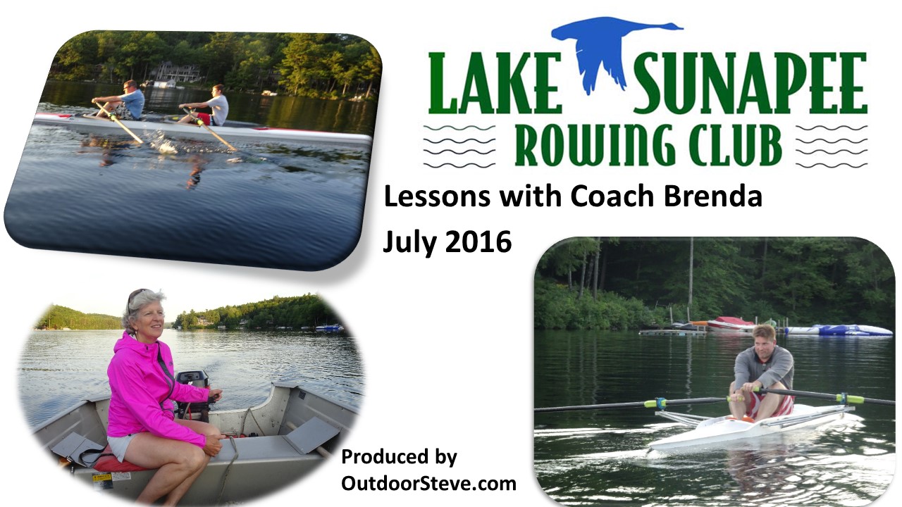
A
proud father and grandfather shares videos of his two sons and grandson taking
July 2016 and July 2015 rowing lessons from the Lake Sunapee Rowing Club
(LSRC http://www.lakesunapeerowing.com).
The 2016 day's class was for the doubles scull and the singles
scull. The LSRC provides the boats (also known as shells).
Lake Sunapee Eight plus Coxswain on Lake Sunapee with Mt Sunapee in background
Our coach, Brenda, is just an amazing instructor
with knowledge, skills, and a lot of patience. Brenda makes the classes
fun with personal instruction for each student, and a wealth of education on
learning the language and techniques of rowing.
Tim and Carson did the doubles scull, while Shaun did
the singles scull. Coach Brenda motored between the two sculls given each one immediate feedback. In addition, while Brenda counseled Shaun and
Tim at the end of the evening, she had Carson get into a single scull, and with
a brief tutorial, Carson was sent on his way into Lake Sunapee to adjust to the
single scull. After Brenda's session with Shaun and Tim, she rowed in
a single scull beside Carson to instruct him in his first single scull lesson.
See a nine-minute video of this 2-hour lesson by Coach Brenda.
In 2015 Tim and Carson, and their friend Nicholas, took lessons in the Eight plus coxswain boat with LSRC. Below is a 5-minute video of the 2-hour lesson.
Now, Shaun, Tim, Carson and Nicholas have experienced lessons offered by the Lake Sunapee Rowing Club.
So where is OutdoorSteve in his rowing this year?
I had the privilege of participating in the 2016 Prouty Rowing doubles rowing event on the Connecticut River starting at the Dartmouth College boat house. As representatives of the Lake Sunapee Rowing Club, my teammate Dave and I, under the excellent tutelage of LSRC coaches, trained for the month of June and early July for two hours every Tuesday, Thursday, and Sunday. http://outdooradventurers.blogspot.com/2016/07/the-prouty-lake-sunapee-rowing-club.html
Along with the Prouty training, a friend asked if I wanted his unused single scull. His offer was readily accepted, and from June till the middle of September, I managed to do a one-hour every other day row in my single scull. The very positive results of this committed training will be discussed in a future blog.
Shaun
Tim
Carson
Nicholas
Steve
Single
Scull
√
√
√
Doubles
√
√
√
Quad
√
Eight
Plus
√
√
√
√
What is Rowing/Crew?
Here is the definition by River City Crew: The term "crew" is often used when talking about rowing. This term is commonly misused, so this may clarify the truths of the names of the sport. "Crew", as a noun, can refer to either the people in a specific high school or collegiate rowing boat or the entire sport of rowing in high school or college. The term "crew team" is redundant and is not properly used. After college, the term "crew" is no longer used to describe the sport or people in a boat, and "rowing team" or "rowing club" is proper. In the sport of rowing, "crew" is never, ever properly used as a verb, i.e., one does not "go crewing", rather one would "go rowing". When in doubt, the noun "rowing team" or verb "rowing" will always be correct when describing the sport.
Rowing is truly a sport which can be done throughout one's lifetime.
What is Rowing/Crew?http://www.rivercitycrew.com/about/3127/ ++++++++++++++++++
"Everyone must do something. I believe I will go outdoors with family and friends"
Steve's 5th book, Outdoor Play Fun 4 4 Seasons Volume II, is now available (2016). Order by clicking OutdoorSteve.com.
Outdoor Play Volume II has trip preparations, routes, and narratives of bucket list places to go. The book will motivate friends and family to make the outdoors a key component of their daily life. If you want 5 or more books signed, send Steve an email send Steve an email and we can work out the logistics. Order at
Welcome to the world of
Outdoorsteve and friends. In early May my son Tim, and our friend Mike hiked the
Tuckerman Ravine Trail in the White Mountains of northern New Hampshire. Our quest was to see downhill skiers ski the Tuckerman Ravine headwall.
Tuckerman Ravine is one of New Hampshire’s unique natural resources. Tuckerman Ravine is a vast open bowl perched on the southeast slope of Mount Washington, the highest mountain in the Northeast at 6,288 feet. In the spring snow depths in the Ravine can reach 100 feet .
Needless to say, Tuckerman Ravine is a very dangerous area subject to avalanches and falling massive blocks of ice the size of automobiles. It also is very exciting and challenging for skiers and outdoor enthusiasts. The open porch of the Hermit Hut shelter is a great place to watch the skiers. How do I get to ski Tuckerman Ravine?
Tuckerman Ravine can
only be reached by hiking uphill for two plus hours - there is no ski lift, road, or method of
access - other than to hike.
We start our hike (if we
were skiing the Ravine we would be carrying our ski equipment) at the
Appalachian Mountain Club’s Pinkham Notch Hut on Route 16. The uphill 2.5 mile hike starts with a boulder laden path that turns into a snow and ice packed trail to Hermit Hut at the base of Tuckerman Ravine.
Once reaching the Hermit
Hut Shelter, extreme alpine, snowboard, and telemark skiers continue to climb
another hour or so up to the headwall of the Ravine’s various self-made ski
lanes. Skiing the Ravine is definitely not for the novice or intermediate
skier. Taking the wrong trail down, or
falling on the ski, can lead to disaster – read this as serious injury or death.
To see a graphic of
Tuckerman Ravine ski routes go to Time for Tuckerman. These ski routes from the top of the ravine can reach 40 - 55 degrees at their steeper sections.
Seeing these talented
skiers on Tuckerman Ravine is a bucket list item. Hermit Hut is a place to talk to these local
“skier celebrities” and hear their personal conquests is worth the 4 to 5 hour round trip hike.
Pinkham Notch (el 2,032
ft) on Route 16, via the Tuckerman Ravine Trail ascends to Hermit Lake (el
3,875 ft). Approximate hiking time is 2 ½ hours in most books, however this hiking time depends on the physical
condition of the slowest hiker to handle jumping boulder to boulder, weather, and
time of year (read snow and ice in winter, and running streams down the Trail
in spring).
Our hike was in early May
with snow melt of small streams frequently crossing the Trail for the first half of the trip
(1 ½ hours), and then ice and snow for the second half (1 1/4 hours. All in all this trip took nearly 3 hours for us to reach Hermit Hut Shelter.
Our hike back to Pinkham
Notch Hut via the same trail was about 2 hours. Enjoy the below video of our hike.
Microspikes or Crampons?
My video says we used "crampons" on the trail. In fact we used
"microspikes". To learn the difference go to Microspikes or Crampons? For most hikers today in the Whites microspikes have replaced crampons - but some of the older
hikers still refer to crampons when they indeed wear microspikes.
Ski runs in Tuckerman
Ravine are steeper than routes at nearby developed ski areas. Adding to the
challenge, as noted, Tuckerman Ravine skiers must work for their runs by hiking
uphill for 2-1/2 miles or so to reach the ravine. There is no ski lift, no snow
grooming, and no indoor shelter at Tuckerman Ravine. But “Skiing Tuckerman”
does boast some of the most challenging terrain in the eastern U.S., making it
a magnet for accomplished skiers and snowboarders, and legions of spectators
who also make the climb to take in the scene. Weather
and trail conditions at Tuckerman and the Tuckerman Ravine Trail can also be
found by clicking on the "Conditions" tab at outdoors.org."
Purchase at www.amazon.com and www.outdoorsteve.com
About OutdoorSteve
OutdoorSteve is more than just a blog; it is a way of life. OutdoorSteve is Steve Priest sharing his outdoor adventures and life experiences. OutdoorSteve includes blog posts, books, short stories, videos, lectures, and speaking events. To learn more or to book Steve for your next event email Steve atsteve@outdoorsteve.com or visit him on the web at OutdoorSteve.com
Outdoor Enthusiast provides outdoor places to go and things to do. Steve's mission is to motivate and encourage families and individuals to make the outdoors a key component of their daily life.
Readers are encouraged to post and share their Comments.
When trying to explain my enthusiasm for outdoor actions, I paraphrase Thoreau's, "Discover I had not lived" with the expression, "Never say, 'I wish I had'."
The book provides places to go and things to do, but moreover the author’s stories and “I wish I had…” show individuals can, like the author, overcome self-made barriers and obstacles of health, physical, mental, and injury problems.
My outdoor pursuit began after a torn Achilles tendon, a resultant limp, and weight gain. I turned to physical activity in search of a stress reliever as well as a "lifestyle for the long haul."
My writings on 'Outdoor Play' enthusiastically portray the entertainment of the outdoors. Travel with me and meet the challenges of outdoor recreation that are the cornerstone of my lectures and stories.
I reside in Sunapee, New Hampshire with Catherine, my wife. We have two sons and two grandchildren.
If you're interested in having me speak, you can email me at steve@outdoorsteve.com or visit www.outdoorsteve.com.