Monday, November 3, 2014

October 18 - 19, 2014 Goffstown, NH Giant Pumpkin Regatta


This 20 minute video documents the wonderful celebration of Fall shared with the local communities by the town of Goffstown, New Hampshire.  A giant pumpkin weigh-in Saturday morning (the winner was 1,284 lbs) was followed by an afternoon of carving and decorating a selection of these same giant pumpkins in preparation for the next day' s Sunday afternoon Giant Pumpkin Regatta.

A Giant Pumpkin Regatta is a unique experience to see as captains dressed in unique costumes paddle inside giant 1,000 lb pumpkins up the Piscataquog River in a race solely for bragging rights "For best giant pumpkin boat."


Day 1
  • Morning Giant Pumpkin Weigh-off (Winner 1,284 lbs)
  • Afternoon Carving and Decorating of the Giant Pumpkins for the Sunday's Giant Regatta
  • Apple Slink Shot Contest
  • Learning to use a Fire Extinguisher
  • Physical Exercise Contest
  • Giant Pumpkin Boat Building
  • Fireman Mini-muster
Day 2
  • Pie Eating Contest
  • Small Pumpkin River Race
  • Giant Pumpkin Regatta
Click below to see the two days of the Pumpkin Regatta:


To see additional links on this event go to another post of Outdoor Steve's Blog at http://outdooradventurers.blogspot.com/2011/10/goffstown-nh-giant-pumpkin-weigh-off.html.

More of Outdoor Steve's blog posts can be seem at http://www.outdoorsteve.com.


-----"Everyone must do something.  I believe I will go outdoors with family and friends"-----

Steve’s latest book, Outdoor Play "Fun 4 4 Seasons" is available as an e-Book at Kindle ($3.99) and hard copy at Amazon.com ($11.95)


Monday, August 25, 2014

Knife Edge Trail to Baxter Peak at Northern Terminus of Appalachian Trail


Six friends planned a long day of hiking, only to find a day and evening of climbing.  The plan seemed relatively simple:

1. Hike to Baxter Peak, the northern terminus of the 2,162 mile Appalachian Trail (AT).
2. Cross the fabled 1.1 mile Knife Edge Trail.
3. Hike five miles on the AT starting at its northern beginning at Baxter Peak.

Our ultimate achievement through endurance and teamwork brought more satisfaction because of the challenges and time on the mountain.  Below are comments, maps, pictures, and videos of our climb. Our Mt. Katahdin accomplishment was both physically demanding, and mentally tough.  I am extremely proud of my fellow adventurers and how we worked together for this team triumph.


Mount Katahdin is the highest mountain in Maine at 5,269 feet. Named Katahdin by the Penobscot Indians, the term means "The Greatest Mountain".  It is part of the Appalachian Mountain range and is located in Baxter State Park.  Baxter State Park is a large wilderness area permanently preserved as a state park, located in Piscataquis County in north-central Maine. It covers 327 square miles.


The Knife Edge was the highpoint of our trip, but the descent from Pamola Peak was nearly as challenging as we had to use technical rock climbing skills.

Our trip started at Roaring Brook campground on the Chimney Pond Trail at 6:45 am.  We arrived at Chimney Pond Campground after a 2 hr 45 minute hike.  From the Campground we took Dudley Trail to Pamola Peak.  We had to do a 40 foot rock straight down climbing descent grabbing cracks in the granite rocks while seeking spots for footholds.  Then immediately followed up by climbing straight up 40 feet to Chimney Peak.  FYI, counterintuitively up is easy because gravity isn’t pulling you down and you and can see where to put your feet.  Admittedly this 80 feet was the most challenging section for this author.  Once atop Chimney Peak we climbed and scooted the 1.1 mile Knife Edge Trail.  This brought us to South Peak.  Our 15 hour trip was an unrelenting 11 miles. We finished the last two hours with headlamps.

Enjoy the below videos of our Mount Katahdin hike.


More Detail Videos of Knife Edge, Google Route, and Overview on Our Katahdin Trek


Below is the time and miles breakdown by trail:


Trails
Start
End
Total Trip Hrs:Min

Hours 


 Miles

Comments
Roaring Brook Campground to
Chimney Pond Campground
Start 6:45 am

9:30 am
2 ¾ hrs

3.3 miles
Chimney Pond Trail easy hike.  4 of us used Tracking Poles.  Some nice side trail views.
Chimney Pond Campground to Pamola Peak via Dudley Trail
10 am
1 pm
3 hrs

1.4 miles
After a snack and rest at Chimney Pond Campground, we tied our tracking poles to our packs.  The Dudley Trail is a 2,000 elevation gain and a relentless massive granite boulder laden trail nearly straight up requiring our hands for pulling, grabbing rocks and hand holds, our legs for pushing, our arms for lifting our bodies, our feet for pushing and toe holds, and our butts to sliding up and holding our bodies at times.
All of us were exhausted.  Indeed it was a very trying physical test of our mettle.
Pamola Peak to Chimney Peak/Knife Edge
1:20 pm
2:12 pm
¾ hr
Our descent down the 40 foot drop from Pamola Peak was technical “rock climbing” .  We held indentations in the rocks while reaching for footholds.  Indeed for this descent we used using hands, arms, body and butt.
Knife Edge to South Peak
2:12
3:00 pm
1 hr

.8 miles
A 1.1 mile balancing act along the ridge of the Knife Edge Trail. Prior to this trip I had visions of panicking because of the elevation and 1000 foot drop offs and extremely narrow trail.  Truthfully, I had no fear as I crossed this very unique trail.
South Peak to Baxter Peak
3:00
3:50 pm
1 hr

.3 miles
This ridge trail went up and down.  Just when we got to the top of the trail, it would drop and we would start another descent.  Then an ascent followed by another descent.  We were close to 7 hours since we left Roaring Brook campground and were tired.  At each high ledge we could see Baxter Peak, but could not differentiate the rolling ridge.
Baxter Peak  via Hunt Trail through Table Land
4:00 pm
5:15 pm
1 ¼ hr

1.0 miles
Tableland was like a country hike.  It was flat and a welcome hike.  We passed the famous Henry David Thorough Spring. We had been hiking for near ten hours. 
Hunt Trail after TableLand to Katahdin Stream Campground
5:15 pm
10:00 pm
4.5 hrs

4.2 miles
We were now headed down and home, BUT still had 4.2 miles according to the trail sign. The first two miles were a steep down and over rough granite.  We did have some technical areas.  One section had steel handles in the granite to make the descent from huge ledges a bit easier.
Took us two hours just to get below the tree line.
At 8:30 pm we put on our headlamps.  We used our trekking poles to give us stability through the downward rock strewn path.

At 10 pm we reached the ranger check-in station where we signed-on the register that six of us were back. We also met the Park Ranger who had been told by two people who passed us earlier in the dark with headlamps and that we were fine and on our way
TOTAL HOURS
6:45 am
10:00 pm
11 miles

 15 hrs!


What a Journey!!!


Knife Edge Trail
We were into our hike for about 6 ½ hrs. of rock strewn, rugged and prolonged steepness,  on the Dudley trail, reaching Pamola Peak, followed by a technical Pamola descent, we ascended Chimney Peak, the start of the almost mile high Knife Edge Trail.  Whew!

The Knife Edge Trail is perhaps the most spectacular trail in New England – and also the most dangerous.  It would take us two hours to cross from Chimney Peak to Baxter Peak. 

We were advised to avoid the Knife Edge in stormy weather.  The exposure to high winds and lightning is extreme.  We were warned once we decide to cross the Knife Edge we MUST CONTINUE ON THE TRAIL. There is no safe way to descend off either side of the mountain ridge.

The mile long path stretches across the South Basin’s headwall between Pamola and Baxter Peak.  I believe you will get a sense of what these six outdoor enthusiasts experienced crossing this unique narrow mile-high ridge with 1,000 foot drops on both sides.  At one point for about 20 feet the width of the ridge was close to 10 inches. The views, when we dared a birds-eyed glimpse, are magnificent and certainly breathtaking.

Are You Ready for Katahdin?


A very special thanks goes to Linwood and Betty of Loons Nest (http://www.loonsnest.biz/) for their immense help in preparing this trip.
Click this link to SUBSCRIBE to OutdoorSteve's YouTube Channel

References


----------------------------------
"Everyone must do something.  I believe I will go outdoors with family and friends"

Steve’s latest book, Outdoor Play "Fun 4 4 Seasons" is available as an e-Book at Kindle ($3.99) and hard copy at Amazon.com ($11.95)

Sunday, August 17, 2014

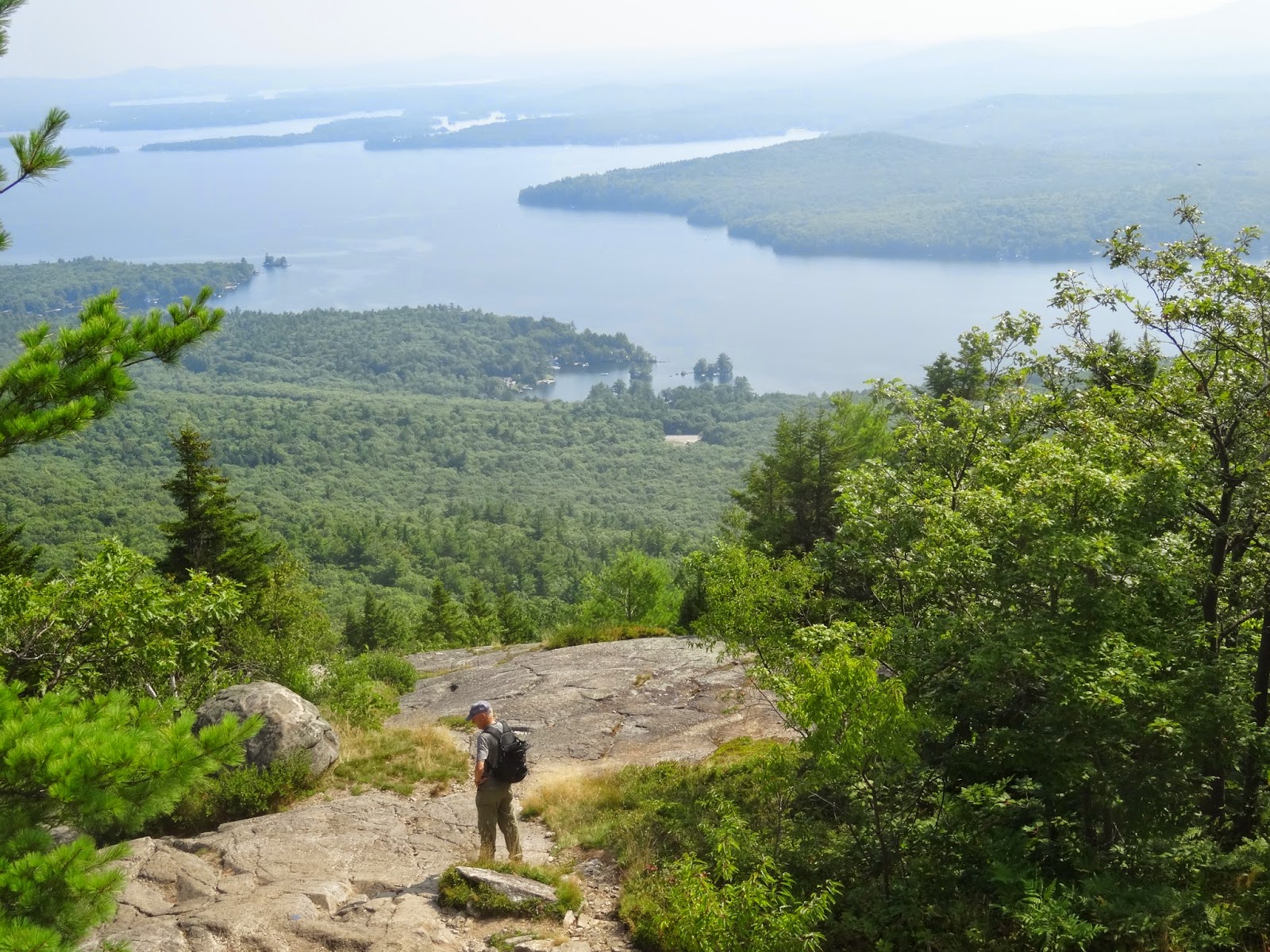
Hiking Mount Major for a Panorama View of Lake Winnipesaukee


Lake Winnipesaukee
from Summit of Mount Major


Mount Major is 1,785 feet in elevation and located in central New Hampshire.  It overlooks Alton bay on the southwest shore of Lake Winnipesaukee.

George and I took a loop trail beginning and ending at the parking lot off of route 11. From the back, left-hand corner of the Route 11 parking lot, we took the orange blazed Boulder Loop Trail. Boulder Loop Trail is about 1.6 miles from the parking lot to the summit of Mount Major.

Boulder Loop Trail climbs easily at first then gets steeper with ledges and huge boulders requiring at least one squeeze through. After a final steep climb, we began to see some views of Lake Winipeasaukee.  It took about another 15 minutes to reach the summit and the remains of a stone built hiker hut.  Our total time form parking lot to summit was about 90 easy going minutes.

The granite laden summit overlooks beautiful Lake Winnipeasaukee. The view below to our right is Alton Bay with an across the lake vjew of the town of Wolfboro.  We take in the breath-taking sights of some of the 258 islands on the lake, and its 182 mile shoreline.  The lake is 72 square miles, and about 21 miles long and 9 miles at its widest point, so we just got enough taste of the beauty of this gem of New Hampshire

Our Descent from the summit was on the blue blazed Mt Major Trail.  The Boulder loop orange-blazed trail junctions with the blue blazed trail Mt Major trail at the summit (be aware the Beaver Pond Trail also meets at the summit to check your map.)

Our total trip was about 3 hours which includes a half hour on the summit.  Certainly this is a family hike mountain for all ages.

Statistics
Elevation: 1,785' (544m)
Prominence: 187' (57m)
Location = Central New Hampshire, USA
Area of water surface = 72 square miles
Number of islands = 258
Distance around lake = 182 miles
Height above sea level = 504 feet
Overlooks Lake Winnipesaukee
  
References


------------------------------------
"Everyone must do something.  I believe I will go outdoors with family and friends"


Steve’s latest book, Outdoor Play "Fun 4 4 Seasons" is available as an e-Book at Kindle ($3.99) and hard copy at Amazon.com ($11.95)

Wednesday, July 30, 2014

Ocean Kayaking in the Deer Isle Region of the Maine Coast – Stonington to Isle au Haut


The Deer Island Region of the Maine Island Trail
The Maine Island Trail (MIT) is a 375-mile chain of over 180 wild islands along the coast of Maine.  In mid-July friends Dundee, Cully, David and I did a three day paddle on the MIT in the Deer Island Region.  The Deer Isle Region extends from Stonington south to Isle au Haut and east into Blue Hill Bay.  We tented two days on the two acre Steves Island (name by coincidence.)

We put-in at Stonington, Maine at the Old Quarry Ocean Adventure campground.  Click the video below for exciting footage of our trip, including a Google Earth map of our MIT route.


Here are some special notes on our trip
  • Over the years, the pronunciation of “Isle au Haut” has drifted considerably. Nowadays, people who have spent time on the island pronounce it “i-la-HO.”
  • Dundee was both our Chef and Navigator.  He is top-notch in both areas.
  • Where are we in the Atlantic? A map and compass are mandatory in these Deer Island
    waters.  Admittedly we had moments where we were questioning the name of the islands we could see in the distance.  Certainly, when fog is present (frequently), you either stay on a known island, use your map and compass to get to your next island destination, or back to the mainland.
  • Disposal of human waste
    • The Maine Island Trail Association (MITA) requests all island visitors carry off solid human waste and dispose of it safely on the mainland.  The Maine Island trail Guide lists several good carry off methods to help you deal with human waste on the Trail.  We chose the Crap Wrap method.
  • Water
    • We brought our own potable water. The islands we visited had no drinking water - and remember, we were in the ocean. 
  • Day 1 Old Quarry Campground to Steves Island
    • A 4.6 mile paddle from Old Quarry Ocean Adventures campground to the 2 acre Steves Island where we camped for two nights
    • Met Randy and son Steve from Lancaster, PA
    • First come – first camp.  Steves Island 2 acres and three sites – ten max
    • Put-in and Parking at Old Quarry Adventure Campground
    • 90 plus minute paddle from Old Quarry to Steve’s Island.
    • Dave caught Mackerel
  • Day 2 Steves Island to Isle au Haut
    • 11 mile paddle was from Steve Island to Harbor Island, where we walked around the Island.  We continued our paddle pass Merchant Island, Pell Island, Nathan Island, and entered the waterway of the Isle au Haut Thoroughfare.  We had lunch outside the Island Store.  We returned to Steves Island the same route.  The round trip was close to 5 hours with windy and choppy seas.
    • Dundee cooked us McNestlers for breakfast.
    • Paddle to Harbor Island (went ashore), then to Isle au Haunt.  Total paddle back to Steves Island was about 5 hours in windy and choppy waters.
    • Lunch Isle of Haunt at Island Store
    • Found mussels on Steves Island for a feast and invited Randy and Steve to join us.
    • We located mussels on Steves Island.  A warming here must be made about Red Tide
  • Day 3 Steves Island to Crotch Island quarry, pass Stonington and takeout at Old Quarry
    • 6 mile paddle passed the George Head island sandbar in a whoop-de-doo surfing wave.   We visited Crotch Island which was once a world renowned granite quarry.  We went up the “crotch” past hills of waste chunks of granite.  We saw osprey and eagles. We continued along the shoreline of the town of Stonington with its many wharfs of commercial lobster and fishing operations.  Lobster boats have the right of way and we learned this quickly as our final hour coincided when lobster boats returning in mass to sell their day’s work.
    • With expectations of a rain and wind storm on Wednesday night, we decided to curtail out trip.  After a coffee and orange juice, we hada  burrito breakfast of pita bread, eggs, cheese and salsa.
    • Crotch Island and stone quarry.  At the turn of the century, Crotch was one of 33 major island quarries along the Maine coast. They provided work for an estimated 10,000 to 15,000 people, creating a boom-town atmosphere in nearby coastal towns. Crotch Island is an active remnant of what once was a dominant industry and colorful part of Maine’s past.
    • Crotch Island's 450 acres are littered with the rusted relics of its past, and dotted
      with hills of waste rock, chunks of granite that didn't break right and couldn't be used. A steam-powered Brown hoist crane with a 40-foot boom stands rusting near the V-shaped inlet that gives Crotch Island its name.  We saw an osprey nest on a hoist crane.
For those interested in more detail of our Deer Isle Region paddle, Bedford Community TV has an online 25 minute video.

To learn about my 2010 trip on the Maine Island Trail (MIT) visit Sea kayaking and Camping on the Maine Island Trail:  Outdoor Steve’s Blog post of August 2010


The Maine Island Trail Association (MITA)
The Maine Island Trail Association (http://www.mita.org/) MIT is a must membership for any outdoor enthusiast considering an ocean paddle.

As a member of the Maine Island Trail Association (MITA) I enjoy the benefits of an MITA e-newsletter and a MITA Guidebook. Dundee, Cully, Dave and I used this guidebook with its maps and island descriptions to plan our three day 22 mile sea kayak paddle in the Deer Island region of the MIT.

In my 2010 paddle on the Maine Island Trail I emailed the office of the Maine Island Trail Association, and MITA responded answering my questions about island fire permits (there is a telephone number in the MITA online (http://www.guide.mita.org/) and hard copy guidebook); camp site reservations (There is no need for camp reservations on any of the islands - a MITA member has access to all sites on the trail, at any time, unless the guide descriptions indicates otherwise); The Deer Isle overview page of the guide has a list of put-ins available, and we selected Old Quarry Ocean Adventures http://www.oldquarry.com).

----------------------------------------------------------
"Everyone must do something. I believe I will go outdoors with family and friends" S. Priest

Click this link to SUBSCRIBE to OutdoorSteve's YouTube Channel

------------------------------------

Steve’s latest book, Outdoor Play "Fun 4 4 Seasons" is available as an e-Book at Kindle ($3.99) and hard copy at Amazon.com ($11.95)

Friday, July 18, 2014

Vermont Wilderness camping and paddling with family and friends


"Everyone must do something.  I believe I will go outdoors with family and friends"

In early July I did two days of paddling and one night of tenting in the Green River Reservoir of northern Vermont.  My companions were my adult son Tim; my two teenage grandchildren; my friend Dundee and his adult son Paul; and Paul’s two teenage boys and his ten year old daughter.  Our transportation was three kayaks and three canoes.


The below 5 minute video is better than words, but here is a summary:
  • I used the Green River Reservoir web site to identify our preferred camp site and place to make reservations.
  • The nine of us in three cars had a two plus hour trip from Sunapee, NH
  • Access to the Green River Reservoir is only through the Park Ranger Station
  • All camp sites are only accessed via the water
  • We had a half hour paddle to our chosen camp site #25
  • We had intermittent rain throughout the first day, BUT rain in no way hindered our wonderful family and friends trip.
  • Paul was our top notch menu planner and Chef as he did on a prior trip (Paddling the Waters of Quetico Provincial Park in Ontario, Canada).  Paul made a marvelous macaroni, cheese, and hot dog supper – and a great McNestler egg-cheese-bacon-English muffin breakfast.
  • We had three tents and a large camp tarp on site #25.
  • We  decided to see if we could start a fire with flint and steel – and each of us took a turn at this task.  You will see this teaching moment in the videos.
  • This is a magnificent lake to swim in clear and deep water.  The surrounding cliffs leave no shore lines – so a person really must be a swimmer to swim here.  All nine of us are experienced swimmers.
  • NEVER jump into water without first checking for rocks, depths and dangerous obstacles.  See the video for our cliff jumping fun.
  • In the evening we went for a paddle around Big Island (we had stayed on site #33 in 2012 Peak Foliage Paddling and Camping in the Green River Reservoir of Northern Vermont)
  • Wildlife is prominent in this area.  We saw nesting loons, herons, beaver signs, and even moose scat.  We were told eagles were there, but we saw none.   

    No grandfather, father, or friend could have enjoyed a better time.  Life is great!


For those interested in more details of our trip click here for our 25 minute video titled Wilderness camping and paddling with family and friends: Green River Reservoir

About Green River Reservoir
Green River Reservoir became a state park in March 1999 when 5110 acres were purchased from the Morrisville Water and Light Department. This is not your typical Vermont State Park – Green River Reservoir provides camping and paddling experiences in a remote setting. All campsites can only be reached by paddling to them - some are a 1 to 2-mile paddle from the launch site.

The park will remain in its wild and undeveloped condition, with low-impact, compatible recreational use allowed on and around the Reservoir. Management activities will be only those necessary to maintain the property’s character, protect the environment and critical resources, demonstrate sustainable forest and wildlife management, control excessive recreational use, and ensure high-quality outdoor experiences for visitors.

The 653-acre Reservoir includes about 19 miles of shoreline, one of the longest stretches of undeveloped shorelines in Vermont. Access to the park is in the southern part of the Reservoir off of Green River Dam Road. The Reservoir is designated as a “quiet” lake under Vermont “Use of Public Waters Rules.” Boats powered by electric motors up to 5 mph and human-powered watercraft (canoes, kayaks, etc.) are allowed.

There are 28 remote campsites at various locations around the Reservoir. Camping is allowed only at designated campsites and can only be reached by boat. Each remote site has a maximum site occupancy based on the characteristics of the site. There is one designated group campsite that can accommodate up to 12 people. Some campsites are closed each season and rehabilitated due to overuse through the years.


--------------------------------------------------------
"Everyone must do something.  I believe I will go outdoors with family and friends"

Steve’s latest book, Outdoor Play "Fun 4 4 Seasons" is available as an e-Book at Kindle ($3.99) and hard copy at Amazon.com ($11.95)